
(details of each turnpike
trust can be reached by clicking on links at bottom of this page)
Devon
County Topology
Devon is the second largest
The rivers run north / south so any traffic along the peninsular is obliged to cross several valleys; the height of Exmoor, Dartmoor and the Blackdowns concentrated travel into the southern edge of the county. Due to the difficult terrain but perhaps also the relative poverty of the area, packhorses were more common than wheeled vehicles for carrying goods, well into the 18th century. Hence, the roads were particularly narrow and twisting, often running in gullies between steep banks and keeping to the hilly ground rather than the wet, tortuous river valleys..
The county town,
Old Routes through the County
Two old
Turnpike Pattern
Like other counties that were distant from
The
During the latter part of the 18th
century roads across
Major improvements were made to the main
London road by trusts set up to build stretches of totally new roads; a new
route from Ilminster to Honiton being formed in 1807 and a new section of the
route through Taunton was built by the Cullompton Trust in 1813. Cooperation
between the
In the early 19th century the
roads around the seaside resorts of
Bridges were generally the responsibility
of the county; stones marked with a C still stand a short distance either side
many bridges, marking the limits of County responsibility on the bridge
approach. However, several major projects were financed by Private Acts of
Parliament and tolls were levied to allow the loans to be repaid. The toll
bridge over the River Teign at Shaldon was built in 1827 and in the same year
the
The turnpike trusts gave up responsibility
for sections of road that passed through several towns when these were covered
by Improvement Acts for all the streets in particular towns. Paving and
Lighting Acts were implemented in
Like other English turnpikes, the
A map of turnpike roads in Devon shows
the roads for which individual trusts were responsible. (the
list of turnpikes trusts below gives
access to more details on individual Devon-based Trusts and th main table provides
information on individual trusts outside the county). This
Finance of Turnpikes
Several
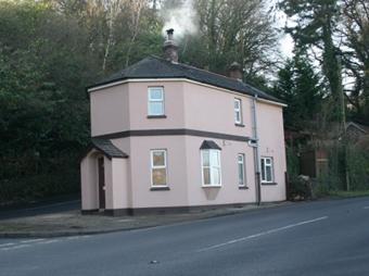
Tollhouses
Click on the highlight to reach a table showing the tollhouses that have been recorded in Devon. About 100 of the original 400 still survive in some form; this is one of the highest number of survivals in any county in the country.
Milestones
The majority of milemarkers erected by the
Devon Turnpike trusts were milestones. In the east of the county, good carvable
stone such as limestone was often used but in the west, harder and less
workable stone such as granite was sometimes used. Each trust adopted a
different pattern of milestone, presumably because they contracted with local
stonemasons who used individual designs. Despite the large mileage covered by
the town-centred turnpikes, only a small proportion of the milestones have
survived from these. However, the Barnstaple Trust, in a final gesture before
handing over responsibility to Highway Boards, commissions new stones to a
common design for the 104 miles of turnpike road for which it was responsible;
many of these Barum stones survive.
 Milestone at Ashcombe,
erected by the Teignmouth and Dawlish Turnpike Trust
Milestone at Ashcombe,
erected by the Teignmouth and Dawlish Turnpike Trust
Individual Turnpike Trusts in Devon
Documents and notes relating to individual Trusts are summarised on pages reached by clicking the links below (only those highlighted in colour are currently on-line).
Combe Martin
Combe Martin and Ilfracombe
Dartmouth, Torquay
and Shaldon
Lyme Regis
(Charmouth to Whimple)
Plymouth and Tavistock (New Road)
Trusts based in other counties but having significant
mileage of roads in Devon
Launceston – (
Saltash (
Wiveliscombe (
The numbers of milestones and tollhouses surviving beside roads in Devon
(note this excludes features such
as guidestones and boundary markers and non-road
markers)
|
Turnpike Trust |
Miles of Road in 1840 |
Milestones found |
survival rate |
Tollhouses in 1840 |
Tollhouse sites
identified |
Surviving tollhouses |
survival rate |
|
Ashburton
(Ashburton & Totnes Consolidated) |
28 |
11 |
39% |
11 |
10 |
2 |
18% |
|
|
104 |
76 |
73% |
12 |
31 |
6 |
50% |
|
Bideford |
42 |
0 |
0% |
10 |
17 |
3 |
30% |
|
Braunton |
|
|
|
9 |
5 |
2 |
22% |
|
Combe Martin |
21 |
0 |
0% |
|
|
|
|
|
Combe Martin and Ilfracombe |
5 |
0 |
0% |
2 |
2 |
0 |
0% |
|
|
2 |
0 |
0% |
1 |
1 |
0 |
0% |
|
Cullompton |
6 |
0 |
0% |
1 |
2 |
1 |
100% |
|
|
7 |
4 |
57% |
2 |
2 |
0 |
0% |
|
|
38 |
17 |
45% |
14 |
13 |
8 |
57% |
|
|
26 |
0 |
0% |
6 |
9 |
1 |
17% |
|
|
147 |
64 |
44% |
25 |
44 |
8 |
32% |
|
Exmouth |
2 |
0 |
0% |
2 |
2 |
2 |
100% |
|
Great |
69 |
1 |
1% |
11 |
11 |
5 |
45% |
|
Honiton |
49 |
8 |
16% |
17 |
16 |
4 |
24% |
|
Honiton and
Ilminster |
15 |
0 |
0% |
3 |
2 |
0 |
0% |
|
Honiton and
Sidmouth |
7 |
2 |
27% |
3 |
2 |
1 |
33% |
|
Kingsbridge and |
56 |
36 |
64% |
19 |
20 |
6 |
32% |
|
Launceston |
8 |
6 |
75% |
|
|
|
|
|
Lyme Regis
(Charmouth to Wimple) |
39 |
8 |
20% |
14 |
12 |
5 |
36% |
|
Modbury |
16 |
7 |
43% |
5 |
6 |
3 |
60% |
|
Moretonhampstead |
16 |
9 |
58% |
4 |
4 |
0 |
0% |
|
|
26 |
16 |
62% |
10 |
8 |
4 |
40% |
|
Okehampton |
38 |
14 |
37% |
5 |
9 |
2 |
40% |
|
|
42 |
|
0% |
3 |
3 |
1 |
33% |
|
|
16 |
|
0% |
6 |
7 |
2 |
33% |
|
|
16 |
3 |
19% |
2 |
3 |
1 |
50% |
|
Saltash ( |
|
|
|
5 |
2 |
0 |
0% |
|
Sidmouth to
Cullompton |
16 |
1 |
6% |
2 |
1 |
1 |
50% |
|
|
42 |
1 |
2% |
7 |
19 |
11 |
157% |
|
Stonehouse |
4 |
4 |
100% |
3 |
9 |
0 |
0% |
|
Tavistock |
51 |
50 |
98% |
12 |
20 |
9 |
75% |
|
|
9 |
0 |
0% |
1 |
1 |
1 |
100% |
|
Teignmouth and
Dawlish |
27 |
16 |
60% |
9 |
9 |
5 |
56% |
|
Tiverton |
88 |
5 |
6% |
27 |
31 |
7 |
26% |
|
Totnes and
Bridgetown-Pomeroy |
44 |
30 |
69% |
12 |
22 |
5 |
42% |
|
Total for
Turnpikes |
1123 |
389 |
35% |
275 |
355 |
105 |
38% |
|
Non-Turnpike
(excl canal and railway) |
8 |
4 |
|
2 |
|
2 |
|
For further reading;
Bennett F. (2007) The Roads of Devon & Cornwall, publ by author Menryn
Burd E.P. (1936) Okehampton Turnpikes, Rep. Trans. Devon Ass. Advan.
Sci, 68,
307-323.
Hawkins M.R. (1988); Devon Roads, publ by Devon Books (
Jenkinson, T. (2007) Old Toll-houses of Dartmoor towns and
villages Part 1: North and west
Jenkinson, T. (2007) Old toll-houses of Dartmoor towns and villages Part 2: South and
Kanefsky, J.
(1976) Devon Tollhouses, Exeter Ind Arch. Group,
Kanefsky, J.
(1977) Railway Competition and turnpike
roads in east
Lowe, M.C. (1990) The Turnpike Trusts of
Lowe, M.C. (1992) Toll Houses of the
Lowe, M.C. (1995) The
Sheldon G. (1928) From Trackway to Turnpike – an illustration from
Sheldon, L. (1933)
Walker H.H. (1963) The Petition for making of the
This page created by Alan Rosevear 16th
Oct 2008.
Last Edited 2nd Feb 2009
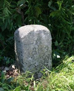
 A Take-off stone at Lydford;
this indicated where the extra horses used to haul a waggon
up a particularly difficult hill had to be taken off – note that this stone may
no longer be in it’s original location and is probably a copy made to replace
the old stone, which was stolen.
A Take-off stone at Lydford;
this indicated where the extra horses used to haul a waggon
up a particularly difficult hill had to be taken off – note that this stone may
no longer be in it’s original location and is probably a copy made to replace
the old stone, which was stolen.