
(details of each turnpike
trust can be reached by clicking on links at bottom of this page)
Cornwall
County Topology
The rivers run north / south so any traffic along the peninsular is obliged to cross several valleys; all traffic must cross the Tamar to enter by road. The height of Bodmin Moor restricted travel down the spine of the county. Due to the difficult terrain but perhaps also the relative poverty of the area, packhorses were more common than wheeled vehicles for carrying goods, well into the 18th century. Hence, the roads were particularly narrow and twisting, often running in gullies between steep banks and keeping to the hilly ground rather than the wet, tortuous river valleys.
The county town,
Old Routes through the County
The main
Turnpike Pattern
Like other counties that were distant from
Thus, by 1770 there were three turnpiked
routes into the county, the road from Okehampton through Launceston, the road
over Dartmoor through Tavistock to Callington and the road from
The
A map of turnpike roads in Cornwall gives
details of the roads for which individual trusts were responsible. (use the
list of turnpikes trusts in the main table for more
details of individual trusts). A list of the Turnpiked routes through
Tollhouses
Click on the highlight to reach a table showing the tollhouses that have been recorded in Cornwall. Almost 50 of the original 180 still survive in some form; this is a relatively high rate of survivals compared with other counties in the country.
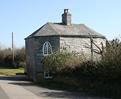 St Breock Tollhouse, nr Wadebridge (a slate
hung building)
St Breock Tollhouse, nr Wadebridge (a slate
hung building)
Milestones
The majority of milemarkers erected by the Cornwall Turnpike trusts were milestones; a few metal posts are found on the road leading from Torpoint Ferry – probably influenced by Plymouth Highways Board.. Unlike other counties, hard and less workable stone such as granite was often used for the milestones. Each trust adopted a different pattern of milestone, presumably because they contracted with local stonemasons who used individual designs.
There are more surviving milestones in
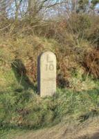 An old Launceston Trust Milestone on the
road to Davidstow
An old Launceston Trust Milestone on the
road to Davidstow
Individual Turnpike Trusts in Cornwall
Documents and notes relating to individual Trusts are summarised on pages reached by clicking the links below (those highlighted in blue are on-line).
Haleworthy, Camelford, Wadebridge and St Columb
The numbers of milestones and
tollhouses surviving beside roads in Cornwall
(note this excludes features such
as guidestones and boundary markers and non-road markers)
|
Turnpike Trust |
Miles of Road in 1840 |
Milestones found |
survival rate |
Tollhouses in 1840 |
Tollhouse sites
identified |
Surviving tollhouses |
survival rate |
|
Bodmin |
57 |
58 |
102% |
23 |
21 |
3 |
13% |
|
Bodmin and Roche |
11 |
6 |
57% |
3 |
2 |
1 |
33% |
|
Callington |
34 |
31 |
91% |
10 |
10 |
4 |
40% |
|
Camelford,
Wadebridge and St Columb |
36 |
24 |
68% |
14 |
8 |
3 |
21% |
|
Creed and St Just |
18 |
7 |
39% |
8 |
4 |
2 |
25% |
|
|
6 |
11 |
183% |
6 |
9 |
2 |
33% |
|
Helston |
26 |
19 |
74% |
9 |
15 |
5 |
56% |
|
Launceston |
46 |
27 |
59% |
16 |
12 |
5 |
31% |
|
Liskeard |
42 |
37 |
88% |
14 |
10 |
7 |
50% |
|
Penryn and
Redruth |
8 |
3 |
37% |
7 |
5 |
1 |
14% |
|
|
10 |
6 |
60% |
3 |
3 |
2 |
67% |
|
Saltash |
20 |
10 |
50% |
22 |
13 |
0 |
0% |
|
St Austell and Lostwithiel |
18 |
24 |
133% |
8 |
7 |
4 |
50% |
|
Trebarwith |
2 |
0 |
0% |
2 |
2 |
2 |
100% |
|
|
56 |
68 |
121% |
32 |
28 |
13 |
41% |
|
Total for
Turnpikes |
389 |
331 |
85% |
177 |
149 |
54 |
31% |
|
Non-Turnpike
(excl canal and railway) |
|
230 |
|
4 |
4 |
4 |
100% |
For further reading;
Bennett F. (2007) The Roads of Devon & Cornwall, publ by author Menryn
Taylor, P.
(2001) The Toll-houses of
This page created by Alan Rosevear 30th Dec
2008.
Last Edited 10th Jan 2009