This was the first turnpike trust in
16 Jan 1754
A petition of Justices, gentlemen, clergy
and principal inhabitants of
That four principal roads branch out from the Borough of Truro,
SW to Penryn,
N to Shortlanesend
W to Redruth, and thence to
E to Lostwithiel passing through Grampound
SE to St Columb passing through Newlyn and St Enoder
These roads have become ruinous and wheeled carriages pass in great danger
Need a bill to erect toll houses and levy tolls.
|
|
created |
27 Geo2 c21 |
1754 |
|
|
|
|
13 Geo3 c112 |
1773 |
|
|
|
|
22 Geo3 c89 |
1782 |
|
|
|
|
42 Geo3 c4 |
1802 |
|
|
|
|
57 Geo3 c44 |
1817 |
|
|
|
|
9 Geo4 c3 |
1828 |
|
|
|
|
11&12 Vic c51 |
1848 |
|
|
|
incorporates |
12&13 Vic c44 |
1849 |
|
An Act for continuing the Term and altering and enlarging the Powers of Two Acts; the One, passed in the Thirteenth Year of the Reign of His present Majesty, for more effectually amending several Roads leading from and near the Borough of Truro, in the County of Cornwall, and for building and keeping in Repair a Bridge over the River at a Place called the Steppings, in or near the said Borough; and the other, passed in the Twenty-second Year of the Reign of His present Majesty, for extending the Provisions of the said former Act to the several other Roads therein described. [24th February 1802.]
An Act for enlarging the Term and Powers of several Acts of His present
Majesty, for repairing certain Roads leading from Truro, and other Roads
communicating therewith, in the County of Cornwall; and for building and
keeping in Repair a Bridge over the River there. [16th June 1817.]
An Act for making, repairing, and improving certain Roads leading to and
from
Earlier Acts were for more effectually amending several
Roads leading from the Borough of Truro in the County of Cornwall
and for building and keeping' in repair
a Bridge over the River at a Place
called the Steppings and the
Roads leading from Short Lane's End in the Parish of Kenwyn to Callestock Burrow, and from
the Two Burrows in the said Parish to Perran Almshouse,
and from the Three Burrows in the said Parish to Saint Agnes
Almshouse, in the said County And whereas considerable Sums of
Money have been borrowed for the Purposes of
the said Acts on the Credit of the Tolls thereby granted, Part of which Money
still remains due and unpaid :And whereas it would be of public Utility
if either the Whole or a Part of a Dwelling House situate on the South Side of
the Eastern End of Bodmin Street in
the Town of Truro, and occupied by Thomas May, were
taken down, and the Scite thereof added to the present Turnpike Road leading
from Truro to and through Grampond; and if a new Piece of Road
were made on the Line of the said present Road
diverging from the Eastern End of Saint Austell Street in Truro aforesaid, and passing through the Parishes of
Saint Clement and Saint Erme to rejoin the said present Road near Kiggon
Bridge in the said Parish of Saint
Erme ; and also if the Trustees having the Care of the said Roads were empowered to discharge themselves
from the Care and Management of all or any Part of so much of the said
present Road as will lie between the
Commencement and Termination of the said intended new Piece of Road: And
whereas the present Turnpike Road leading from Truro to the
Borough of Mitchell (being a Part of the Road leading from Truro, through
the Village of Penhale in the Parish
of Saint Enoder, to Bodmin,) is in some Parts narrow, steep, and incommodious, and it would therefore and
otherwise be of public Utility if a new Road we're made diverging from
the said Road leading from Truro to
and through Grampond at or near the Foot of Truck Hill in
the Parish of Pro bits, and passing by the Northern Valley, through the several Parishes of Prolnis,
Ladoc/c, and Saint Enoder, to join the said Road leading from Truro through Penhale
to Bodmin at Penliale aforesaid: And whereas the present Turnpike Road
leading from Truro to the Borough of Penryn is in some
Parts very steep, circuitous, and
incommodious, and it would be of great public Utility if certain new
Pieces of Road were to be made on the Line thereof; that is to say, a new Piece of Road diverging from the last-mentioned Road near Plynt's Barn, and passing
through the several Parishes of Kemoyn and Kea, to rejoin
the same Road near Killiganoon in the Parish of Feock, about Two
Miles and One thousand four hundred and thirty Yards from Truro ; another
new Piece of Road diverging at Killiganoon
aforesaid, about Three Miles and Five hundred and fifty Yards from Truro, and passing through the
said Parish of Feock, and thence across the Railway and Carnon River and
Carnon Old Stream Works, and thence to and along the North
Side of Perron Creek to Perron Wharf in the Parish of Perran-Arwothal,
to rejoin the same present Road near Rapson's Mill at Perran
Wharf aforesaid; and another new Piece of Road diverging at Belle Vue, and
passing through certain Fields lying Westward of the same present Road in the
Parish of Saint Gluvias, and crossing the same present Road about Two hundred
and thirty Yards below the Penryn Town Turn-pike Gate, and then passing through certain other Fields lying Eastward
of the same present Road in the said Parish of Saint Gluvias and Borough of Penryn respectively, and
over the Head of the Creek, there to join the Turnpike Road leading from
Redruth to Penryn near the Bottom of New Street; or if
(instead of the intended Line last mentioned) a new Piece of Road were made
diverging at the said Turnpike Gate, and
passing through certain Fields lying Eastward of the said present Road leading from Truro to Penryn, and
situate respectively in the said
Parish of Saint Gluvias and Borough
of Penryn, and also over the Head of the Creek, to join the said
Road leading from Redrutli to Penryn
at the Point aforesaid ;and also if the said Trustees were empowered to discharge themselves from the Care and Management of all or any of such Parts
of the said present Road from Truro to Penryn as will lie
between the several Points at which the said several new Pieces of Road
intended to be made on the Line of the same present Road will respectively
commence and terminate : And whereas it
would be of public Utility if so much of the present Highway or Road, leading
from Perron Wharf aforesaid
Westward to the said present Turnpike Road leading from Truro to Penryn, as will lie Westward of the said
intended new Line of Road to Perron
Wharf, were made Turnpike; and if a new Piece of Road were made
branching out of the Turnpike Road last mentioned at the Point, at which the said Highway or Road joins the same present Turnpike Road, and passing through several Fields
in the said Parish of Perron- Arwothal to join the present Turnpike Road
leading from Truro, to and over Tretheage Bridge, at or near Pellean
Bar or Gate in the said Parish of Pcrran-Arwothal ; and if
the Trustees of the said Roads were
empowered to discharge themselves from the Care and Management of all or any Part of so much of the
said Road leading from Truro to and over Tretheage Bridge as will lie
between the Commencement of the said
intended new Piece of Road from Killiganoon to Perran
Wharf and Pellean Bar or Gate aforesaid : And whereas the present
Road leading from Truro to the Chapel Hill Turnpike Gate (being a
Part of the Road leading from Truro to Redruth) is very steep
and incommodious, and it would be of public Utility if a new Piece of
Road were made diverging from the said present
Road leading from Truro to Penryn at or about Sixty Yards beyond
the Barrack Ground, and passing through certain Fields in or near a Westerly
Direction, to join the said present Road leading from 'Truro to Redruth at Chapel Hill Gate
aforesaid ; and if Parts of certain
Houses situate in Kenwyn Street in Truro aforesaid, in the several
Occupations of James Bastian, Samuel Trenerry, Esther Symons, William Rowe, Thomas Walley, John
Knuckey, and Thomas Gilbert Hicks, were taken clown, and a new Piece of Road were made diverging
from the said present Road leading from Truro to Redruth at or
near the Entrance of Bosvigo Lane, and passing through certain Fields in a Westerly Direction, and
joining the same present Road at Bosvigo
Barn ; and in case the proposed Piece of Road last mentioned were made, then also if the said Trustees
were empowered to discharge
themselves from the Care and Management of so much of the last-mentioned
present Road as will lie between the Commencement of the last-mentioned proposed new Piece
of Road and Chapel Hill Gate aforesaid : And whereas it is
expedient that a certain Highway, branching out of the said present Turnpike
Road from Truro to Mitchell near Mitchell Hill Gate, to Morresk
Mill in the Parish of Saint Clement, should
be made Turnpike, and put under the Care of the said Trustees for the Space
of Nine hundred Yards from the same Turnpike Road :
New Act
defines
the present Turnpike Road leading
from Truro aforesaid to Redruth aforesaid; and the
Turnpike Road leading from the present Third Mile Stone on the
last-mentioned Road to a Place called the Three Burrows, in the said
Parish of Kenwyn, and from the Three
Burrows aforesaid to Saint Agnes Almshouse; and also the
present Turnpike Road leading from Truro aforesaid to Penryn aforesaid,
and there falling into the Turnpike Road leading from Redruth to Penryn
aforesaid; and also the present Turnpike Road branching out of the said
Road from Truro to Penryn at Perran-Arwothal, and leading
to and over Tretheage Bridge; and also the present Turnpike Road leading
from Truro aforesaid to the Second Mile
Stone near Short Lane's End in the said Parish of Kenwyn; and also the present Turnpike Road leading from Short
Lane's End aforesaid to Callestock Burrow, on the Cross Road
leading from a Place called Marasanvose to a Place called Zelah in
the Parish of Saint Allen ; and also the present
Turnpike Road leading from a
House formerly belonging to Thomasine
Williams, and now occupied by Diana Crisp Widow,
situate at the Western End of New East Bridge Street aforesaid, formerly called Coinage Hull Street,
in Truro aforesaid, over the New East Bridge, being the Bridge erected in pursuance of
the said first-recited Act over the Steppings aforesaid, and from thence
to the Borough of Mitchell; and
also the present Turnpike Road branching out of the last-mentioned Road at the
Eastern End of New East Bridge Street aforesaid to and through Grampond aforesaid;
and also the present
Turnpike Road branching out of the said Road to and through Grampond, and
leading to Mopas ; and also the said Bridge.
John Tippet of
There are 56 miles 1 furl of road thru 16 parishes – all repaired by the
trustees
32 toll gates
The roads are stated to be in “good” condition – no part under
indictment for want of repair.
Perran Alms
Those marked (*) are not specified in later Acts
Also
And Perranporth Road B3284 has
And St Stithians Road UC has
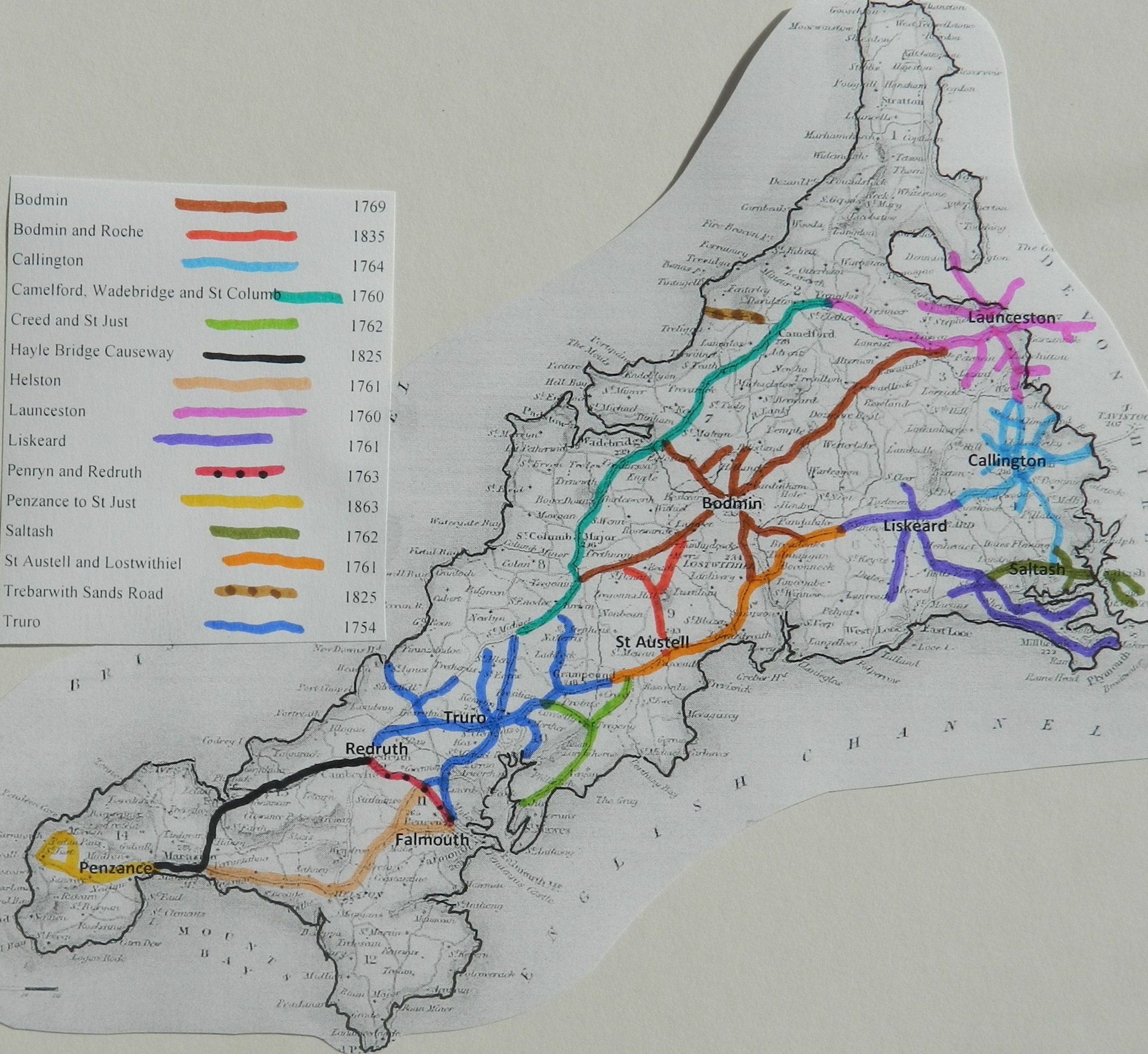
Click
here for a map
of Cornwall Turnpike Roads
Click
here to return to Turnpikes
Home
Return to Turnpikes in Cornwall general
page
|
Road
Classification Number |
Route |
GATE NAME |
OS Grid Ref-
Prefi |
Easting |
Northing |
District |
Civil Parish |
Location (Name or
Number) |
Road or Street
(see across) |
Position |
Evidence |
Revised 24th Sept
2013 |
erected by
(Turnpike Trust or Authority) |
Bibliographic
refs |
|
A39 |
Truro to
Penryn |
Devoran |
SW |
79326 |
39557 |
CWCA |
FEOCK |
The Old
Tollhouse, No. 42 |
Devoran
Lane, Devoran |
up hill
from Carnon bridge |
; ; ; |
Truro |
Taylor P.
(2001), "The Toll-houses of Cornwall", p43 |
|
|
A39 |
Truro to Penryn |
Carnon Bridge
(Devoran) |
SW |
791 |
394 |
CWCA |
FEOCK |
|
Devoran |
close to crossing
of Carnon river |
; ; ; |
Truro |
Taylor P. (2001),
"The Toll-houses of Cornwall", p42 |
|
|
A39 |
Truro to
Penryn |
Carnon
(Playing Place) |
SW |
81003 |
41432 |
CWCA |
KEA |
Skewberries
Farmhouse |
Playing
Place |
on old
road, bypassed by new roundabout |
; ; ; |
Truro |
Taylor P.
(2001), "The Toll-houses of Cornwall", p44 |
|
|
B3284 |
Truro to
Perranporth |
Shortlanesend |
SW |
808 |
477 |
CWCA |
KENWYN |
Shortlanesend |
|
|
; ; ; |
Truro |
Taylor P. (2001),
"The Toll-houses of Cornwall", p43 |
|
|
A39 |
Truro to Penryn |
Water (Penryn
Town) |
SW |
780 |
349 |
CWCA |
PENRYN |
The Praze |
|
|
OS 1st Series; ;
; |
Truro |
Taylor P. (2001),
"The Toll-houses of Cornwall", p41 |
|
|
A39 |
Truro to
Penryn |
Stickenbridge |
SW |
78116 |
39783 |
CWCA |
PERRANARWORTHAL |
Toll House
(now a garage) |
Stickenbridge |
|
; ; ; |
Truro |
- |
|
|
UC road |
Perranwell
to Truro Road |
Perranwell |
SW |
78130 |
39783 |
CWCA |
PERRANARWORTHAL |
|
Tarrandean
Lane |
|
; ; ; |
Truro |
Taylor P.
(2001), "The Toll-houses of Cornwall", p41 |
|
|
A30 |
Mitchell to
Redruth |
Perran Almshouses |
SW |
789 |
494 |
CWCA |
PERRANARWORTHAL |
Perran Almshouses |
|
|
; ; ; |
Truro |
Taylor P. (2001),
"The Toll-houses of Cornwall", p46 |
|
|
B3277 |
St Agnes to
Truro |
St Agnes |
SW |
711 |
515 |
CWCA |
ST AGNES |
The Toll
House |
West
Polberro, Porthtowan |
|
; ; ; |
Truro |
- |
|
|
A39 (A3076) |
Truro to
Mitchell |
Bodrean |
SW |
8389 |
4822 |
CWCA |
ST CLEMENT |
The Toll
House |
Bodrean |
replaced
Buckshead |
OS 1st
Series; ; ; |
Truro |
Taylor P.
(2001), "The Toll-houses of Cornwall", p46 |
|
|
A390 |
Truro to St
Austell |
Tresillian |
SW |
8681 |
4650 |
CWCA |
ST CLEMENT |
The Toll
House |
Main Road,
Tresillian |
by bridge
over Tresillian River |
; ; ; |
Truro |
Taylor P.
(2001), "The Toll-houses of Cornwall", p49 |
|
|
UC road
(was A390) |
Truro
to Redruth |
Chacewater |
SW |
75108 |
44313 |
CWCA |
ST DAY |
Toll
Cottage |
Church
Hill, Chacewater |
|
; ; ; |
Truro |
- |
|
|
UC road
(was A3076) |
Truro to
Mitchell |
Trenerry
(Mitchell) |
SW |
83160 |
45720 |
CWCA |
TRURO |
Trenerry
Toll House |
Bodmin
Road, Truro |
at jct with
Moresk Road (Mitchell Road) |
OS 1st
Series; ; ; |
Truro |
Taylor P.
(2001), "The Toll-houses of Cornwall", p47 |
|
|
UC road
(was A39) |
Truro to
Falmouth |
Calenick |
SW |
8211 |
4312 |
CWCA |
TRURO |
Bridge
House |
Old
Falmouth Road, Calenick |
on north
side of narrow bridge |
; ; ; |
Truro |
Taylor P.
(2001), "The Toll-houses of Cornwall", p45 |
|
|
A39 |
Truro to Mitchell |
St
Clements |
SW |
8384 |
4575 |
CWCA |
TRURO |
|
opp. Old
Isolation Hospital |
at jct with A3076 |
; ; ; |
Truro |
Taylor P. (2001),
"The Toll-houses of Cornwall", p48 |
|
|
A39 (A3076) |
Truro to Mitchell |
Buckshead |
SW |
834 |
463 |
CWCA |
TRURO |
Buckshead |
replaced by
Bodrean |
|
; ; ; |
Truro |
Taylor P. (2001),
"The Toll-houses of Cornwall", p47 |
|
|
A39 |
Truro to Penryn |
Pelynt Barn
(Tolgarrick) |
SW |
821 |
439 |
CWCA |
TRURO |
Pelynt Barn |
Arch Hill, Truro
where the ‘Old Coach Road’ from Playing Place joined the newer road. The toll
house has been demolished to accommodate road improvements |
; ; ; |
Truro |
Taylor P. (2001),
"The Toll-houses of Cornwall", p44 |
||
|
A390 |
Truro to St
Austell |
St Austell Street
(1) |
SW |
8292 |
4488 |
CWCA |
TRURO |
nr the
Roundhouse, 37, St. Austell Street |
|
|
; ; ; |
Truro |
Taylor P. (2001),
"The Toll-houses of Cornwall", p45 |
|
|
UC road |
Truro to Redruth |
Chapel Hill
(Bosvigo) |
SW |
820 |
447 |
CWCA |
TRURO |
Truro to Redruth
road |
|
|
; ; ; |
Truro |
|
|
|
B3284 |
Truro to
Perranporth |
Kenwyn |
SW |
8221 |
4525 |
CWCA |
TRURO |
Kenwyn |
|
|
; ; ; |
Truro |
Taylor P. (2001),
"The Toll-houses of Cornwall", p42 |
|
|
St Austell Street
(2) |
SW |
8298 |
4486 |
CWCA |
TRURO |
St Austell Street |
|
|
; ; ; |
Truro |
- |
|||
|
UC road
(was A39) |
Truro to
Penryn |
St Gluvias |
SW |
77035 |
36808 |
CWKE |
ST GLUVIAS |
Turnpike
Cottage |
The Barns,
Lower Treluswell |
in loop off
road, 2 miles from Penryn |
; ; ; |
Truro |
Taylor P.
(2001), "The Toll-houses of Cornwall", p40 |
|
|
A390 |
St Austell
to Lostwithiel |
Grampound |
SW |
9326 |
4846 |
CWRE |
GRAMPOUND
WITH CREED |
Toll House |
Fore
Street, Grampound |
by bridge
over River Fal |
; ; ; |
Truro |
Taylor P.
(2001), "The Toll-houses of Cornwall", p50 |
|
|
A3058 |
Truro to St
Enoder |
St Enoder |
SW |
90446 |
54279 |
CWRE |
ST ENODER |
Toll Gate
Cottage |
St Austell
Road, Brighton, Grampound Road |
beside
Brighton Cross Nursery |
; ; ; |
Truro |
Taylor P.
(2001), "The Toll-houses of Cornwall", p49 |
|
In the Milestone
Society Database, 68 are identified on A39, A30, A390 B3284, and UC roads, –.
(based on Trust mileage, expect 56 i.e. some side roads may have been included)