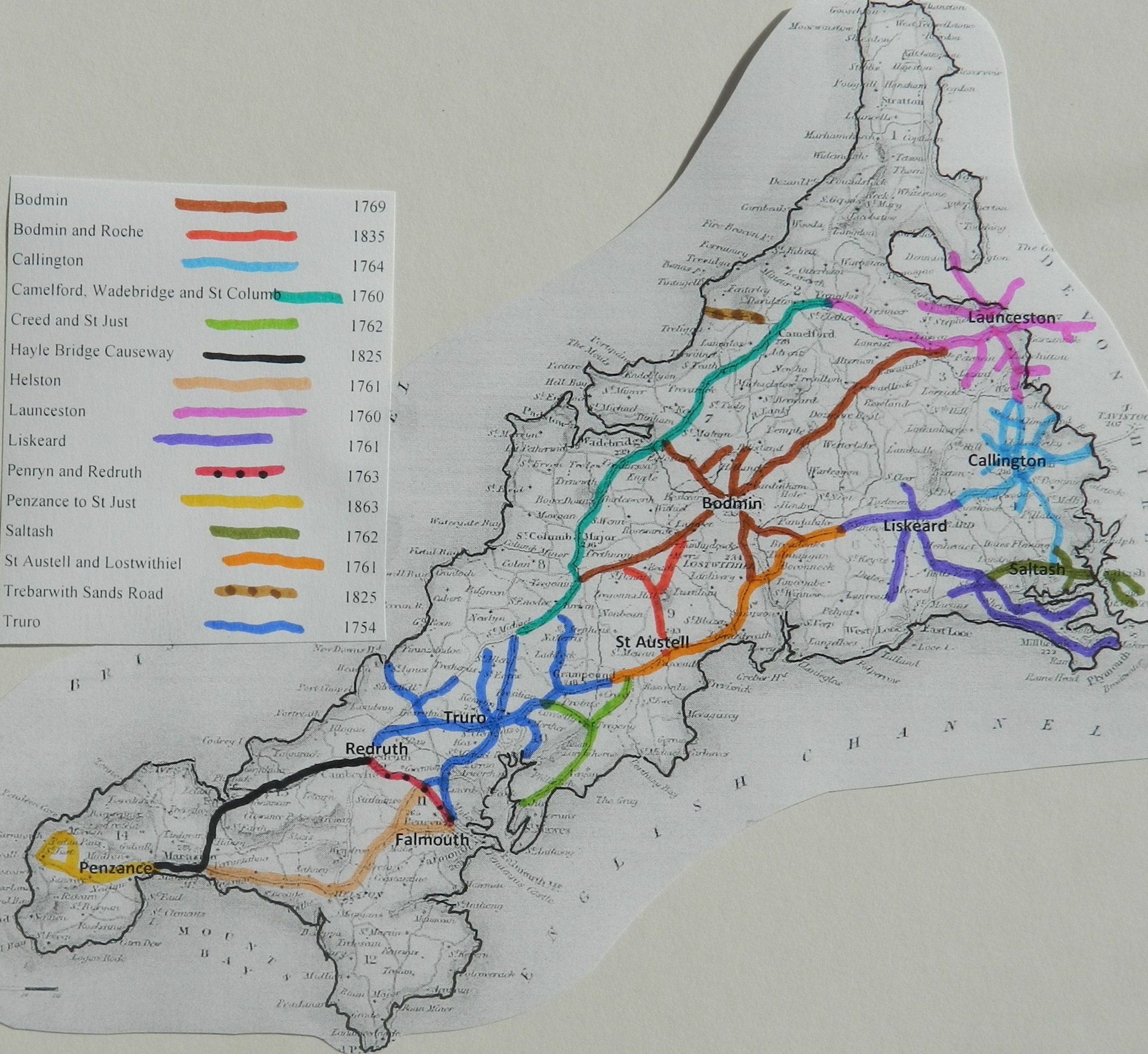
This trust was initially created in 1825 to
improve the main road over the river estuary and give access into the mining areas.
It was later extended to turnpike the highway west of Redruth, towards
|
|
Grigg's Quay, |
6 Geo 4 c4 |
1825 |
|
|
|
Griggs Quay and |
7 Wil4 c2 |
1837 |
|
|
|
Hayle and Redruth
Turnpike. |
2&3 Vic c12 |
1839 |
|
|
|
continuation |
38&39 Vic c194 |
1875 |
|
|
|
termination |
|
|
Nov 1878 |
Hayle 1825
An Act for building a Bridge and making a Causeway and Turnpike Road from or near Grigg's Quay, in the Parish of Uny Lelant, over Hayle River and Sands, in the Parish of Saint Erth, to Carnsew Quay, through Hayle Foundery, in the said Parish of Saint Erth, and Pen Poll, in the Parish of Phillack, all in the County of Cornwall. [23d March 1825.]
WEREAS the Port of Hayle, in the County of Cornwall, is a Place of great Resort, by reason of the extensive
Trade it carries on in Coals, Timber, iron, Lime, and other Commodities,
and the shipping of the various Ores
raised in the numerous Mines in its
Neighbourhood : And whereas the direct
Line of Communication betwixt the
large and populous Towns of Truro,
Redruth, and Camborne, and the
flourishing Town of Penzance, and various other Parts of the said County
of Cornwall, runs through Hayle, and immediately across the Hayle
Sands and River, but, in
consequence of the extremely
hazardous and dangerous State of the
said Sands, and of the utter Impossibility of passing over them for
considerable Periods before and after the
Time of High Water, (they then being
entirely overflown), the Passage is frequently impeded, and Persons going to
and from the Places before mentioned are obliged
to go round by a longer and more hilly
and circuitous Route: And whereas the
making, maintaining, and keeping in repair
a Turnpike Road, and the building of a
bridge, and the raising and forming of a
Causeway, from or near a Place situate at about Eight hundred Feet. South-west
of a certain Wharf or Quay called Grigg’s
Quay, in the Parish of Uny Lelant in the said County, over and
across the said River Hayle and Sands, to or near the Western End or
Termination of a certain Lane called Helston Lane, in the said Parish of
Saint Erth, and the forming, making, and opening of convenient Avenues, Roads, and Approaches to the said
Causeway, and the continuing the said Turnpike Road from the End or Termination of the said Causeway,
at or near the Western End of the said Lane, to a certain Wharf or Quay
called Carnsew Quay, in the said Parish of Saint Erth, and from thence
through a certain Place, called Hayle Foundery, in the said Parish of Saint
Erth, and through Part, of a Tenement called Pen Poll, in the Parish of Phillack, in the said County, in a Direction towards and across the Scite of the Stable of a certain Inn or Public House
called The Royal Standard Inn, which is
situated near certain
Wharfs or Quays called The
Hayle Quays, in the said
Parish of Phillack, to a Point parallel
with the Northern End of the said Inn,
arid there to fall into the present Road or Highway leading from the said Town of Penzance to the said Town of Camborne, would
confer a great Benefit, on the
said Port
of Hayle, by rendering the Access to it safe and commodious for
Travellers and Carriages, would much
facilitate the Conveyance of Goods and Passengers to and from the said
Towns of Truro, Redruth, Camborne, and Penzance, and the Places
adjacent thereto, and in general considerably improve the Communication and
Intercourse between the Central and Western
Parts of the said County
George Dennis John of
There are 6 miles of road thru 5 parishes – all repaired by the trustees
3 toll gates and 3 side gates
The roads are stated to be in “very good” condition – no part under
indictment for want of repair.
Hayle Causeway Road; A30 from Illogan Highway in
Redruth, through Ludgvan to juct with Helston Road at Marazion (about 13 miles
– in 1840 was 6 miles i.e. as far as Copperhouse)
Click
here for a map
of Cornwall Turnpike Roads
Click
here to return to Turnpikes
Home
Return to Turnpikes in Cornwall general
page
|
Road
Classification Number |
Route |
GATE NAME |
OS Grid Ref-
Prefi |
Easting |
Northing |
District |
Civil Parish |
Location (Name or
Number) |
Road or Street
(see across) |
Position |
Evidence |
Revised 24th Sept
2013 |
erected by
(Turnpike Trust or Authority) |
Bibliographic
refs |
|
A30 |
Camborne to
Redruth |
Trewithian |
SW |
636 |
404 |
CWKE |
CAMBORNE |
Trewithian |
|
|
; ; ; |
Hayle Bridge
Causeway |
Taylor P. (2001),
"The Toll-houses of Cornwall", p32 |
|
|
UC road
(was A30) |
Camborne to
Redruth |
Blowing
House (Illogan Highway) |
SW |
68702 |
41763 |
CWKE |
CARN BREA |
Barncoose |
Barncouse
Terrace |
jct with
lane on route of old mineral tramway |
; ; ; |
Hayle
Bridge Causeway |
Taylor P.
(2001), "The Toll-houses of Cornwall", p33 |
|
|
A30 |
Camborne to
Redruth |
Pool |
SW |
6658 |
4141 |
CWKE |
CARN BREA |
Cornwall Technical
College |
The toll house
probably controlled the road at a point where there was a mineral tramway
crossing. It stood in the grounds of Cornwall College until it was demolished
|
; ; ; |
Hayle Bridge
Causeway |
Taylor P. (2001),
"The Toll-houses of Cornwall", p32 |
||
|
UC road
(was A30) |
Camborne to
Redruth |
Connor
Downs |
SW |
59194 |
39210 |
CWPW |
GWINEAR
GWITHIAN |
|
Turnpike
Road, Connor Downs, jct with Mutton Hill |
; ; ; |
Hayle
Bridge Causeway |
Taylor P.
(2001), "The Toll-houses of Cornwall", p31 |
||
|
A30 |
Camborne to
Redruth |
Hayle |
SW |
5604 |
3763 |
CWPW |
HAYLE |
|
|
|
; ; ; |
Hayle Bridge
Causeway |
Taylor P. (2001),
"The Toll-houses of Cornwall", p31 |
|
|
A30 |
Camborne to
Redruth |
Crowlas |
SW |
5144 |
3309 |
CWPW |
LUDGVAN |
Crowlas |
jct with B3309 |
|
; ; ; |
Hayle Bridge
Causeway |
Taylor P. (2001),
"The Toll-houses of Cornwall", p30 |
|
|
A30 |
Camborne to
Redruth |
St Erth |
SW |
5419 |
3590 |
CWPW |
ST ERTH |
opp. station |
|
|
; ; ; |
Hayle Bridge
Causeway |
Taylor P. (2001),
"The Toll-houses of Cornwall", p30 |
|
|
A30 |
Camborne to
Redruth |
Hayle Causeway 1 |
SW |
5464 |
3629 |
CWPW |
ST ERTH |
|
|
|
; ; ; |
Hayle Bridge
Causeway |
|
|
|
A30 |
Camborne to
Redruth |
Hayle Causeway 2 |
SW |
5513 |
3660 |
CWPW |
ST ERTH |
|
|
|
; ; ; |
Hayle Bridge
Causeway |
|
|
In the Milestone
Society Database, 11 are identified on old A30 now UC roads, (based on Trust mileage, expect 6 i.e. some
side roads may have been included)