Bodmin Turnpike Roads (updated 24th Sept
2013)
This trust was created in 1769 as a
town-centred Trust covering roads in mid-Cornwall. Its primary responsibilities
were; (a) the
List of
Acts
|
Bodmin |
|
9 Geo3 c69 |
1769 |
|
|
Bodmin |
Adds Lanhydrock
road to Lostwithiel |
51 Geo3 c159 |
1811 |
|
|
Bodmin |
Adds |
10 Geo4 c19 |
1829 |
|
|
Bodmin |
New sections to
replace old road |
3&4 Wil4 c89 |
1833 |
|
|
Bodmin |
|
5&6 Wil4 c105 |
1835 |
|
|
Bodmin |
|
29&30 Vic c140 |
1866 |
|
|
Bodmin |
Expired |
37&38 Vic c95 |
1874 |
Nov 1874 |
Bodmin 1811
An Act to continue and amend Two Acts of His present Majesty for repairing several Roads
leading to and through the Borough if
Bodmin, in the County of Cornwall;
and for amending certain other Roads
passing through the said Borough and the
Parish of Lanhydrock, in the said County. [l0th June 1811.]
Bodmin 1829
An Act for more effectually making
and repairing certain Roads leading to and from Bodmin, and
certain other Roads therein mentioned, in the County of Cornwall [13th
April 1829.]
widening, altering, diverting,
improving, and keeping in repair such of the aforesaid Turnpike Roads as at the
Time of passing this Act are maintained and repaired by virtue of the Powers
and Authorities of the said several recited Acts hereby repealed; (that is to
say),
the Road leading from the Butter Market in the Town of Bodmin aforesaid,
through the Borough of Bodmin, and the several Parishes of Bodmin,
Cardinham, Temple, Saint Neot, Alternon, and Lewannick, over Hick's
Mill Bridge, to Kennard's House in the Parish of Southpetherwin, commonly called the Launceston Road;
and from the said Butter
Market to the
and from the said Butter Market to Pimligoe in
the said Parish of Helland, commonly called the
and from the said Butter Market, through the Borough
and Parish of Bodmin, and the several Parishes of Lanivet, Luxulion,
Roach, Saint Columb Major, and so far as
Higher Fraddon at the Western End of Fair Mile Commons in the Parish
of Saint Enoder, commonly called the Truro Road ;
and from the said
Butter Market, through the Borough of Bodmin, over Dunmeer Bridge,
through the Parishes of Bodmin and Egloshayle, to Trenant
Lane End in the said Parish of Egloshayle, commonly called the
and from the said Butter Market, through the said Borough of Bodmin and the Parish of Landydrock,
over Resprin Bridge, and through the Parishes of Saint
Winnow and Broadoak, so far as where the Bodmin Road near the
Four Burrows joins the Road
leading from Lostwithiel to the Town of Liskeard, commonly called
the Liskeard Road;
and from the said Butter Market, through the said
Borough of Bodmin, and the Parishes of Landydrock and Landlivery,
so far as Noman's Land in the said Parish of Landlivery, commonly called the Lostwithiel and Saint
Austell Roads;
and to and from the said
Butter Market, through Prior's Barn Lane in the said Borough of Bodmin, to Prior's Barn Turnpike
Gate, and from thence near to a Place called Carminow's Cross, through
the Borough of Bodmin and the Parish of Landydrock, to the
Turnpike Road leading from the Town of Bodmin to the Borough of
Liskeard,
and from a side Gate adjoining to the Turnpike House
at Prior's Barn Turnpike Gate
aforesaid called Cooksland Gate, over Cooksland Common, through the said Borough of Bodmin, near to Callywith Turnpike
Gate, commonly called the
Prior’s Barn Road ;
and also for making, completing, ad maintaining
several new Pieces or Lines of
Road, or Diversions from the aforesaid
old Roads; that is to say, a new
Piece of Road commencing at the Brewery
Lane in the said Borough, through Prior’s
Barn Lane, and through certain Inclosures
adjoining the said Lane,
to and over Cooksland Common, to join the present Turnpike Road at or near to the One Mile Stone
from Bodmin to Launceston; a new Piece of Road
diverging from or near the Five Mile Stone from Bodmin to Launceston, through the Estate of Greenborough and
Menacrin Marsh, to or near to the
Seventh Mile Stone, to join the present
Turnpike Road from Bodmin ;
a new Piece of Road
diverging from the present
Turnpike Road at Fire Lanes, over and through
the present Highway leading from
five Lanes aforesaid to Plasha Cross, and from thence through certain Inclosures over
Two Bridges to or near to Holloway Cross Turnpike
Gate in the Parish of Southpetherwin to join
the present Turnpike Road from Hick's Mill Bridge to Launceston;
a new Piece of Road diverging from the
present Turnpike Road near Carminow's Cross, over the Common near to Black
Pool and down the Valley under
or near Dreeson Ball to Resprin Bridge,
to join the present Turnpike Road from Bodmin to Liskeard;
a new
Piece of Road commencing at the Place
where Polmawgan Lane joins the
present Bodmin Turnpike Road, and
through the said Lane to some Inclosures in the Possession of James
Stephens and others, and from thence over the Common to join
the
present Turnpike
Road at or near the
Five Mile Stone from Bodmin to Liskeard;
a new Piece of Road diverging from the present Turnpike Road near Townsend Turnpike
Gate, through Dark Lane, crossing the Turnpike Road to Dunmeer at
or near the One Mile Stone from Bodmin, down the Valley to Boscarne Bridge, and
passing near to Nanstallan Mill, over Mulberry Downs, through Tremoor
and Rosewarrick to Colbiggen Corner, to join the
present Turnpike Road from Bodmin
to Truro, with a new
Piece or Branch of Road from Nanstallan Mill aforesaid to Polbrock;
and also a new Branch from the said new Piece of Road before described from
Bodmin Townsend Turnpike Gate to Colbiggen
Corner, commencing at the Western
End of Dark Lane, through and over certain Inclosures in the possession
of James Webb, to a lane or highway leading from the town of Bodmin to Tan
Wood, and from thence through the said lane to the County Gaol of
Bodmin.
Bodmin 1833
An Act for
amending an Act of His late Majesty King George
the Fourth, for more effectually making and repairing certain Roads
leading to and from Bodmin, and
other Roads therein mentioned, in the
County of Cornwall, and for making and maintaining a new Road communicating
therewith. [10th June 1833.]
it would be very beneficial to the
Public that the new Pieces or Lines of
Road in the said recited Act mentioned and
herein-after described should be
made and completed ; (that is to say,) a new Piece of Road commencing-
at the Brewery Lane in the said Borough, through Prior's Barn Lane, and
through certain Inclosures adjoining the said Lane, to and over Cooksland Common, to join the present
Turnpike Road at or near to the One
Mile Stone from Bodmin to Launceston; a new Piece of Road
diverging from the present Turnpike Road near Carminow's Cross, over the
Common near to Black Pool, and down
the Valley under or near Dreeson Ball to Resprin
Bridge, to join the present
Turnpike Road from Bodmin to Likeard; a new Piece of Road
commencing-at the Place where Polmawgan
Lane joins the present Bodmin Turnpike
Road, and through the said Lane to some Inclosures in the Possession of James
Stephens and others, and from
thence over the Common to join the
present Turnpike Road at or near the Five Mile Stone from Bodmin to Liskeard;
a new Piece of Road diverging from the
present Turnpike Road near Townend Turnpike Gate:, through Dark Lane,
to join the present Turnpike Road to Dunmeer at or near the One Mile
Stone from Bodmin (being Part of a new
Piece of Road in the said recited
Act, comprised); and also a new Branch
from the said new Piece of Road before described from Bodmin Townend Turnpike
to Dunmeer aforesaid, commencing at the Western End of Dark Lane aforesaid,
through and over certain Inclosures then in the Possession of
James Webby to a Lane or Highway leading from the Town of Bodmin to Tanwood, and from
thence through the said Lane
to the County Gaol in Bodmin aforesaid;
Select Committee on State of Roads 1840
Christopher Wallis of Bodmin (clerk to the trust) reported
There are 57 miles of road thru 21 parishes – all repaired by the
trustees
23 toll gates
The roads are stated to be in “good repair” – no part under indictment
for want of repair.
Report to Secretary of State 1866
BPP 1866; No. 2.-BODMIN ROADS.
The present Local Act for these roads, of the 5th and 6th of William IV.
cap. 105., repealed the previous Acts of the 10th of George IV. cap. 19, and
the 3rd and 4th of William IV. cap. 89, authorized the making of some new
roads, and granted a new term which will not expire until the end of next
session.
The total-length of the roads at present belonging to this Trust is 54
miles 7 furlongs 88 yards, as under :—
|
|
Total length of road Miles. Fur. Yds. |
Within the town of Miles. Fur. Yds. |
Number of gates and bars Gates Bars |
|
No.
2. Ditto Branch No. 3. No. 4. No. 5. No. 6. No. 7.
Lostwithiel and No. 8.
———————Branching out of No. 9——————— |
17 7 110 0 2 0 0 4 44 1 5 110 12 1 0 6 1 132 5 2 132 0 4 176 0 5 0 9 5 44 |
0 1 32 0 2 44 0 5 44 0 1 132 |
4 4 1 0 3 1 2 1 3 3 2 1 |
|
|
54 7 88 |
1 2 132 |
15 10 |
The portions of road within the town of
Two tolls
are payable on road No. 1, but payment at any gate on the other roads clears all the gates on the same line of road.
The full rates of toll are levied; there are no weighing-machines on any of the roads.
The money borrowed, some portions of which were advanced as long ago as
1769, was stated in 1840 as being £8,870, but in the
following year bonds for £200 were relinquished, and various payments have since been made whereby the amount
has been reduced to £3,630 which
remains due in fifteen sums, as mentioned in the schedule to the bill; £3,330
bears interest at £5 per cent., but on £300 no interest is payable.
The accounts show that the toll receipts fell off in 1848, and again in
1851, in which year a stage coach which had been running daily over a large
portion of the Trust road was converted into a mail coach, and so became exempt
from toll; the increased receipts in 1860 were occasioned by a great competition
for the toll-gates in consequence of the opening of the Cornwall
Railway. The funds have been expended,—in the repair of the roads;-—salaries
(£15 to treasurer, £35 to clerk, £80. to surveyor);—law charges
(including, in 1844, the costs occasioned by an appeal to the Quarter Sessions
against a conviction for
the evasion of the tolls; and, in 1846, the costs of prosecution against
parties for pulling down a fence and making
a road for the purpose of evading the tolls) ;—interest of -debt;—improvements (prior to the year
1851);—portions of the principal;—and incidentals
(under which head was included, in 1855, the expense of sinking a well at one
of the toll-houses, and in 1862, the costs of widening a dangerous part of the
Wadebridge Road).
No correspondence has taken place with reference to this Trust, but on
the 19th of December, Sir George Grey received a copy of a resolution passed by
the Trustees on the 9th of October, as follows :—
The surveyor of the Trust having now submitted the plans and estimates
for altering and diverting portions of the Dunmeer and Crowan Hills, on the
line of road belonging to the Trust leading from Bodmin to Wadebridge and
Camelford, by which it appears those hills will be greatly improved, and the
increasing traffic on that line of road rendering such improvements very
necessary,—
It was resolved, That the clerk do at once give the necessary notices
and take the necessary steps for applying to Parliament for a renewal of the
Act of this Trust for twenty-one years, and for including therein such
alterations and improvements in Dunmeer and Crowan Hills respectively."
In the present application it is proposed to repeal the existing Act,
and to obtain additional powers for a term of twenty-one years.
In the preamble it is stated that the present Act will expire at the end
of the session of Parliament next after the 20th day of August 1865 ;—this
should be the 21st of September 1866; it is also stated that some of the pieces
of road authorized to be made by the present Act, have not been made, and have
been long since abandoned.
Clause 12 describes the Trust roads as at present existing,—but as most
of them are described as commencing at the Clock Turret in Bodmin, some
portions are referred to more than once.
Clause 13 describes the two new pieces of road proposed to be
made,—these pieces of road are diversions of the present road, and are in
length, respectively, 2 furlongs 110 yards, and 3 furlongs 44 yards, total 5
furlongs 154- yards ; the preamble states that the estimated cost of
constructing these new portions is £900.
List of Roads
Launceston Road; A30 (in parts now UC bypassed
roads) from jct with A395 at Kennard’s House, west of Launceston, over Hick’s Mill
Bridge, across Bodmin Moor, to Bodmin Butter Market (about 17 miles)
Lostwithiel and
Click
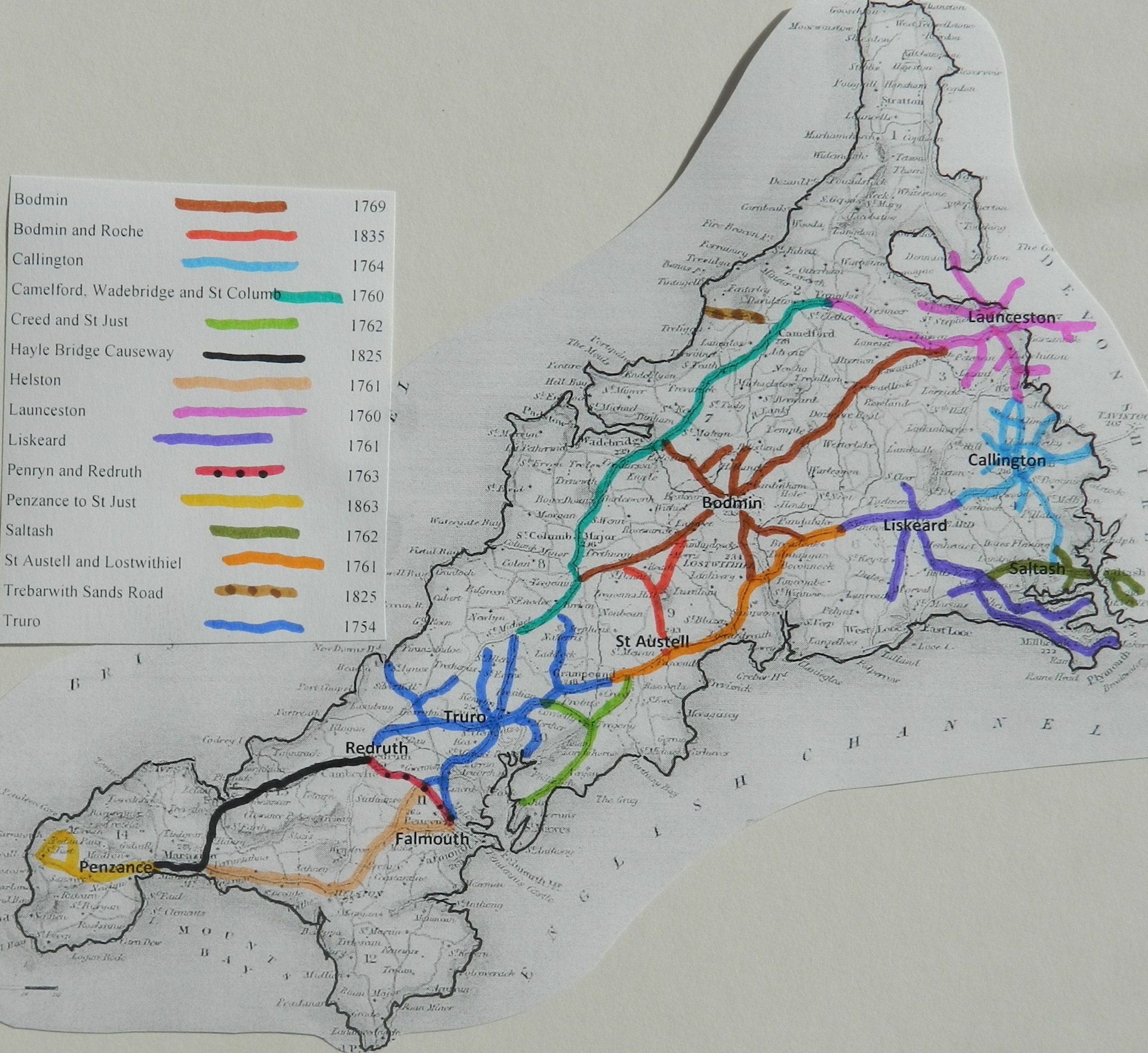
here for a map
of Cornwall Turnpike Roads
Click
here to return to Turnpikes
Home
Return to Turnpikes in Cornwall general
page
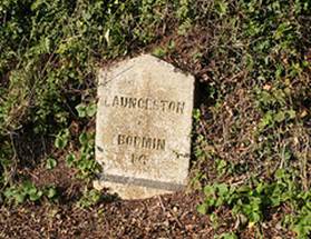 Typical Milestone on the Bodmin Turnpike Trust at Altarum – a design
referred to as Bodmin Gable
Typical Milestone on the Bodmin Turnpike Trust at Altarum – a design
referred to as Bodmin Gable