Wayside markers before the Turnpikes Trusts
Finding the way in
unfamiliar territory has always been an important concern for the traveller.
Asking local people the way was a common remedy, but markers erected by the
roadside were important, particularly where no-one lived. Wayside markers
provide a prominent feature where a decision had to be made, such as at a
junction, crossing or pass. Standing stones, some shaped into crosses to make
them more distinctive, still survive at remote crossings in the upland areas of
Another early type of
wayside marker indicated where a boundary was crossed. These are not limited to
roadsides, but a roadside boundary marker could be used to provide additional
guidance to the traveller. This was especially the case when the boundary was
for a responsibility related to the road; the Oxford Mileway Markers that
indicated the limits of responsibility for highway maintenance are a good
example.
Although a few Roman
Milestones have survived, it is unlikely that they are in their original
position and these have been excluded from this assessment.
The table below
summarises the numbers of wayside markers that have been recorded in the
Milestone Society database. The following sections describe the main categories
of wayside markers from the period before roads were turnpiked. The data in the
table suggests that only a small proportion of the wayside stones that are
visible today date from a period before the turnpikes began to erect milestones
in the 1740s.
Old Wayside Markers
It is difficult to
judge how widespread the use of wayside markers was across
Adaptation of natural
features, the piling of stones to form
Wayside Crosses may be the earliest category of man-made
wayside marker. In the far Southwest and on the
The enthusiastic
recording of surviving crosses and publication of several books and web sites
demonstrate that the majority of the surviving crosses are in the upland areas
of Southwest Britain; Dartmoor, Bodmin Moor, Wendron and West Penwith (Starkey
provides a good Gazetteer for Devon and Andrew Langdon a series of
comprehensive Gazetteers for Cornwall). The older wheel-headed crosses, which
have a Celtic feel to them, are more common in the far west, whereas the cross
heads in Devon are generally of a Latin style (a distinction between traditions
on either side of the Tamar). Many of these crosses are now on tracks that are
no longer regarded as highways, or have been removed to churchyards, so are not
routinely recorded in the main Milestone Society database. However, lists of
potentially surviving crosses, drawn up from published sources, can be found by
clicking on Wayside Crosses in
Cornwall or Wayside Crosses
in Devon. There are a number
of crosses amongst the surviving standing stones in the
Photographs of
surviving Wayside Crosses are illustrated on the Flickr site;
http://www.flickr.com/groups/1068319@N22/
and; http://www.flickr.com/photos/tollhouses/sets/72157614609050819/
The Stone Crosses
of Devon, outside the
Guide Stoops or Guide Stones are the other large group of early waymakers.
After the Dissolution, secular charities and donors took on the
responsibilities for some highways and bridges, previously dealt with by
ecclesiastical bodies. A few examples of elaborate memorial markers survive
from this period. In
Guide stoops survive
in greatest number on the
Other upland areas
have early guide stones, though they are generally less impressive than those
on the
Early Fingerposts may have been made of wood and so the
originals have long decayed; the survivors such as at Chipping Campden are
clearly replacements. There are two 18th century fingerposts made of
more durable material in Gloucestershire and elsewhere place names including
the word “hands” suggests there were several more.
Boundary Stones beside the road span a wide period of time.
Dartmoor is typical of upland
Some boundary stones
relate specifically to responsibilities of maintaining a road. Although bridges
and causeys were very prominent examples of finance by charitable bequests,
some sections of road were also maintained by donations. The limits of these
highways needed to be clear and an example of this survives at Stowood in
Oxfordshire. The Oxford Mileway Stones mark the limits of road that was to be
repaired and maintained by contributions from parishes adjoining
True Milestones, which are regularly spaced along a route,
were erected between 1712 and 1733 on the road between Barkway and
A look through the English Counties
at Listed monuments and notable items
CAMBRIDGESHIRE – 16
Trinity stones
DERBYSHIRE – a wayside
cross over 50 guide stoops
DEVON – 7
GLOUCESTERSHIRE – 3 early
fingerposts
HEREFORDSHIRE – 1 wayside
cross
KENT –
LEICESTERSHIRE – 1 wayside
cross
OXFORDSHIRE – 4 Oxford
Mileways markers;
SOMERSET –3 Listed wayside
crosses; ; 4 road end stones
Summary table of pre-turnpike wayside markers in English section of MSS
database
|
COUNTY |
Guess at Total surviving milestones |
Pre-Turnpikes Wayside markers beside road |
Additional Notes on wayside
features that are off road and not recoded in database |
|
BEDFORDSHIRE |
18 |
0 |
|
|
|
102 |
0 |
|
|
BUCKINGHAMSHIRE |
147 |
0 |
|
|
CAMBRIDGESHIRE |
138 |
16 |
|
|
|
295 |
0 |
Several stone crosses |
|
|
500 |
193 |
Plus ca 200 wayside crosses beside
road and on moors and possibly more guide stones on moors |
|
|
260 |
0 |
Several Viking crosses |
|
DERBYSHIRE |
188 |
54 |
Many dated 1709 to 1739 – may be
other off road |
|
|
400 |
17 |
Plus ca 100 wayside crosses beside
road and on moors and possibly more guide stones on moors Some wayside crosses |
|
|
228 |
0 |
Plus 2 wayside crosses |
|
|
155 |
0 |
|
|
|
119 |
0 |
|
|
GLOUCESTERSHIRE |
220 |
0 |
Campden, Teddington and Toddington
hands |
|
HAMPSHIRE |
335 |
0 |
|
|
HEREFORDSHIRE |
250 |
1 |
|
|
HERTFORDSHIRE |
90 |
0 |
Though see Cambridge Trinity set |
|
|
140 |
1 |
1 wayside cross memorial |
|
|
110 |
2 |
possibly more guide stones on
moors |
|
LEICESTERSHIRE |
72 |
1 |
|
|
|
140 |
0 |
|
|
MIDDLESEX |
65 |
0 |
|
|
|
350 |
0 |
Several wayside cross memorials |
|
NORTHAMPTONSHIRE |
30 |
0 |
|
|
NORTHUMBERLAND |
210 |
0 |
|
|
NOTTINGHAMSHIRE |
35 |
0 |
|
|
OXFORDSHIRE
* |
190 |
6 |
|
|
|
10 |
0 |
|
|
|
300 |
0 |
|
|
|
280 |
4 |
Plus 3 wayside crosses |
|
STAFFORDSHIRE |
387 |
0 |
|
|
|
150 |
0 |
|
|
|
165 |
1 |
|
|
|
65 |
0 |
|
|
WARWICKSHIRE |
45 |
0 |
|
|
|
112 |
0 |
|
|
|
400 |
28 |
Plus 133 guide stones that may be
of turnpike era but not erected by trusts - possibly more guide stones on
moors |
|
|
144 |
13 |
Plus 11 guide stones that may be
of turnpike era but not erected by trusts - possibly more guide stones on
moors |
|
|
340 |
22 |
Plus 55 guide stones that may be of
turnpike era but not erected by trusts - possibly more guide stones on moors |
|
WILTSHIRE |
380 |
0 |
|
|
WORCESTERSHIRE |
230 |
0 |
|
|
|
7795 |
359 |
many |
Examples
of Pre-turnpike Wayside markers
|
|
|
|
|
|
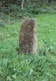
Potential Guidestone
at roadside on edge of |
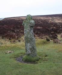
Bennet’s
Cross – a Wayside Cross, later used as a warren boundary, beside a |
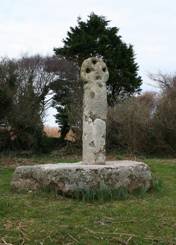
Three Hole Cross,
Egloshayle, |
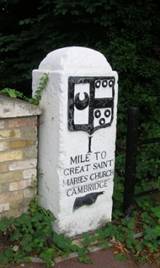
Pre-turnpike,
Trinity milestone, |
|
|
|
|
|
|
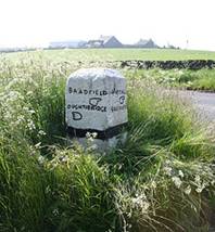
Guide Stoop in the
Parish of Bradfield |
Guide Stoop with
hands in the Parish of Bradfield |
Shaft of a Saxon
cross from the moors above Bakewell |
|


This page created by Alan Rosevear 4th March 2009.
Last Edited 4th June 2009.