
Dorset
County Topology and Wealth
In Dorset,
the Wessex Downs dominate the landscape to the northeast, heathland to the east
and deep sided river valleys to the west. Although there are several wide river
valleys such as the Stour and Frome, none
creates a significant barrier to travel. The southern boundary of the county is
a long coastline with significant harbours at Bridport and Poole.
Weymouth was an
important resort for the rich in the 19th century.
In the 18th and 19th
centuries, the main commerce of Dorset was in
agricultural produce with small manufacturies based on these in the market
towns.
The county town, Dorchester, is 120 miles
from London.
Old Routes through the County
The old Post Road to Exeter was mapped by Ogilby.
Turnpike Pattern
Turnpiking of the main roads was relatively
late, perhaps reflecting the relatively good soil conditions on the Downs and
Heaths of Dorset as well as the distance from London. Part of the Great Western Road that runs through the
northern part of the county was turnpiked through Sherborne and Shaftesbury in
1753. The ancient east/west arterial route, through Blandford Dorchester and
Bridport was turnpiked in two Acts of 1754 & 1756 and turnpiking in the
rest of the county then proceeded rapidly during the 1760s.
The turnpiking of the central route through
Dorchester followed a similar pattern to that elsewhere in the south of England. The
main road between the major market towns was improved to assist long distance
through traffic and secondary routes into these towns were turnpiked later
under separate Acts. However, Dorset also includes several town-centred trusts,
which were a particular feature of the Western England.
The Sherborne and the Shaftesbury trusts (created by the division of the first
1753 trust) took into their control a web of secondary and tertiary routes that
converged on the market town. As a result they were responsible for very high
mileages of road and needed large numbers of tollhouses. It is evident that
these minor routes generated little income and were expensive to administer;
individual tollhouses took very little over the cost of running. This suggests
that improving access to local markets (Sherborne, Shaftesbury, Wareham) and seaports (Poole and Weymouth)
was more important so far away from London,
whereas closer to the capital main roads to the London markets dominated.
The tradition Post Roads linking the
Southwest to London
continued to be the preferred routes for long distance traffic including the
Mail coaches. The relatively small number of tollgates on these turnpikes
generated large sums of income which could be applied to road maintenance and
improvement of the existing route. In the early 19th century new
roads were created by new trusts to avoid intractable problems on older routes.
The last major route to be turnpiked was the new east/west road, The Wimborne
& Puddletown turnpike, through Bere Regis in 1840. This was created
relatively late in the turnpike era and just before the railways transformed
travel in Victorian England. Building roads over the high ridges that formed
the watersheds on rivers in the west of the county was challenging and
considerable sums were needed to ease gradients and make new cuts to avoid
unstable or steep sections of road. Two Dorset
trust chose to adopt a very radical solution and cut road tunnels through the
ridges at Horn Hill Beaminster and at Thistle Hill Charmouth. These were
pioneer engineering projects, both of which were opened in 1832.
A map of turnpike
roads in Dorset gives retails
of the routes and the year in which individual turnpike trusts were created
(use the list of turnpikes trusts in the main table
to identify the name of individual trusts). This Dorset
county view is based on a line map of roads by Ronald Good, with information on
the individual trusts added in different colours.
Finance of Turnpikes
Although toll income on the Great Western Road
was relatively high, the costs of maintaining the road in the western part of
the county left trusts with significant mortgaged debt. The income of
subsidiary routes was quite low, made worse by the proliferation of tollhouses
and turnpiking of minor roads around urban centred truss and the Stour Valley
turnpike (Vale of Blackmoor).
Tollhouses
Many of the tollhouses in the southern part
of the county were constructed from brick; those around Bridport being
particularly striking. In the north, stone build tollhouses were more common
(typically along the Shaftesbury and Sherborne Roads) Click on the highlight to
reach a table showing the tollhouses that
have been recorded in Dorset.
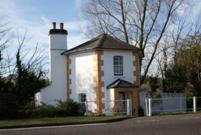 Tollhouse at Charminster, north of
Dorchester
Tollhouse at Charminster, north of
Dorchester
Milestones
Milestones were initially of stone but on
the secondary routes cast iron plates were attached to these in the 19th
century. The shape of these plates varied between trusts.
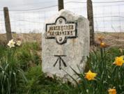 Milestone with iron plate, between Dorchester and Sherborne
For further reading;
David Viner (2007) “Roads, tracks & turnpikes”,
in the Discover Dorset series published by Dovecote Press, Wimborne.
This page created by Alan Rosevear 16th Oct 2008.
Last Edited 16th Oct 2008