(details of each turnpike trust can be reached by clicking on links at bottom of this page)


Berkshire (the pre-1974 County)

County Topology and Wealth

Berkshire lies to the west of London. The River Thames forms a long convoluted northern boundary and the ground rises to the west and south onto Downland with wet river valleys running mainly east/west. A flat clay Vale bounded to the north by a low limestone ridge forms the NW sector between Abingdon and Faringdon and rather infertile forest around Windsor forms the SE sector. The main tributaries of the Thames, the rivers Ock, Kennet and Loddon were easily bridged from early times at Abingdon, Reading and Twyford but the Thames was a more significant barrier to travel.


In the 18th and 19th centuries, the main commerce of Berkshire was in agricultural produce (particularly in the Vale) and forestry (around Windsor) with small manufacturies based on these in the market towns. There are a number of wharfs on the Thames (Abingdon, Reading, Henley and Maidenhead) where goods can be transferred to barges for carriage to London.


There were a number of large country houses with wealthy residents alongside the Thames and travellers to Bath from London had to pass through this county.


The county town, Reading, is 40 miles from London.

Old Routes through the County

Roman roads running west from London with an important hub at Silchester but the majority of these routes were lost by Medieval times. The Saxon highway from Mercia to Wessex ran south from Oxford and several important routes for carrying wool to Channel ports ran south across the upper Thames bridges. Ogilby’s Great Road to Bristol ran the length of the county and important cross roads radiating south and west from Oxford.


A number of ancient bridges crossed the Thames (Wallingford was the lowest reliable ford). These influenced the pattern of travel along the Thames Valley. The building of Abingdon Bridge allowed traffic heading westwards to travel across the Vale to St John’s Bridge, avoiding the long journey northward around sweep of the Thames around Oxford.


Turnpike Pattern

The earliest turnpikes in Berkshire were primarily related to improvements on the Bath Road. First section west of Reading was turnpiked in 1714 with other sections following rapidly so by 1728 almost all of this major London radial road through Berkshire was under turnpike trusts. The Great Road to Worcester which branches to the northwestwards at Maidenhead was turnpiked in 1728 and the Great Road to Gloucester which in turn branches from this was almost all turnpiked by 1730s.


Major changes in pattern resulting from the building of new bridges over the Thames. Most important were the bridges at Shillingford in 1764 and at Eynsham in 1767; new turnpikes ran across each of these and in both cases routes new north/south routes down into Hampshire were created soon afterwards in 1771/2.


Reading was the principal hub of the county road network but individual trusts were responsible for the different types of route. The road to Basingstoke (1718) carried agricultural goods to the Thames wharfs. The Hatfield road (1768) was a short cut for passenger traffic from north of London to Bath and the routes across Windsor Forest (1759) provided an alternative passenger route into London. However, the Bath Road was the principal axis for travel and in 1826 the trusts around Reading were reorganised to give a more rational structure by the formation of the Theale trust to take over the turnpikes west of the town and the Twyford Trust those to the east.


The last turnpike Act to create a new road in Berkshire was in 1832, although it is unclear whether this Windsor to Twyford turnpike ever functioned.


A map of turnpike roads in Berkshire gives retails of the routes and the year in which individual turnpike trusts were created (use the list of turnpikes trusts in the main table to identify the name of individual trusts). This Berkshire county view is based on a revision of the line map of roads in the Berkshire Historical Atlas, with information on the individual trusts added in different colours.


Finance of Turnpikes

The topology made the roads of Berkshire relatively easy to maintain and high traffic flow provided ample toll income to finance the turnpike trust works on the Bath Road. The minor routes running north/south had more difficult ground and there was less traffic so these trusts were less sound financially. The Aldermaston to Basingstoke Trust in particular got into serious financial difficulties and was the cause of some local scandal.

Tollhouses

Several very elegant tollhouses on the Bath Road. Brick is the most common building material. Virtually all Berkshire tollhouses have gone. Tidmarsh, an octagonal building in polychromatic brick is the best surviving example. Click on the highlight to reach a table showing the tollhouses that have been recorded in Berkshire.


Milestones

Milestones are predominantly of stone, almost all imported into the area. There are particularly elegant markers in Bath stone along the Bath road.


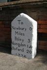
 Milestone dated 1776 at Beedon on the

main road south from Oxford across Berkshire.


Click on the link for the draft text for a booklet on the Turnpike Roads of Reading and East Berkshire. There is an associated Appendix containing speculation on the route of Roman Roads in South Berkshire.


Individual Turnpike Trusts in Old Berkshire

Documents and notes relating to individual Trusts are summarised on pages reached by clicking the links below (those highlighted in blue are on-line).

Abingdon and Fyfield

Abingdon, Wootton to Swinford

Besselsleigh

Chilton Pond and Abingdon

Forest Road (not a TP)

Fyfield, Newbridge and St John's Bridge

Harwell and Streatley

Hinksey Road

Hurley

Leckford or Sousley Water

Maidenhead

Maidenhead to Cookham

New Windsor and Twyford

New Windsor to Datchet

Reading and Basingstoke

Shillingford and Reading

Speenhamland to Marlborough

Speenhamland to Reading

Theale Road (Reading to Puntfield)

Twyford

Twyford and Theale

Wallingford, Wantage and Faringdon

Windsor Forest


Trusts based outside the County with significant mileage in Berkshire


Reading to Hatfield

Newtown River to Chilton Pond

Faringdon to Acton Turville


 The numbers of milestones and tollhouses surviving beside roads in Old Berkshire

 (note this excludes features such as guidestones and boundary markers and non-road markers)

Turnpike Trust

Miles of Road in 1840

Milestones found

survival rate

Tollhouses in 1840

Tollhouse sites identified

Surviving tollhouses

survival rate

Abingdon  and Fyfield

6

4

67%

1

3

0

0%

Abingdon, Wootton to Swinford

10

0

0%

1

1

0

0%

Besselsleigh

22

18

82%

4

8

0

0%

Chilton Pond and Abingdon

8

4

48%

2

3

0

0%

Fyfield, Newbridge and St John's Bridge

16

5

32%

3

9

0

0%

Harwell and Streatley

9

7

81%

3

3

0

0%

Hinksey Road

8

3

40%

1

4

0

0%

Hurley

5

4

80%

1

1

0

0%

Maidenhead

9

10

108%

1

2

0

0%

Reading and Basingstoke

18

5

28%

4

3

0

0%

Shillingford and Reading

18

11

61%

4

4

0

0%

Speenhamland to Marlborough

11

10

88%

1

1

0

0%

Speenhamland to Reading

9

8

91%

1

1

0

0%

Twyford and Theale

18

13

72%

6

4

1

17%

Wallingford, Wantage and Faringdon

25

27

108%

4

16

0

0%

Windsor Forest

17

7

42%

3

7

1

33%

Forest Road (not a TP)

10

5

50%

0

0

0


218

136

63%

40

70

2

5%

Newtown River to Chilton Pond

9

9

100%

1

1

0

0%

Faringdon to Acton Turville

16

13

83%

2

1

0

0%


County References

For further reading;

A Rosevear (1995), “Roads across the Upper Thames Valley”. A series of 15 booklets, Privately published


This page created by Alan Rosevear 16th Oct 2008.

Last Edited 21st Dec 2009.