This trust, created in
1727, was one of the earlier turnpike trusts in
|
|
|
13 Geo1 c12 |
1727 |
|
|
|
Powers to
prosecute gate breakers |
3 Geo2 |
1730 |
|
|
|
|
22 Geo2 |
1749 |
|
|
|
Stoke Bishop to Shirehampton, and road to Aust |
31 Geo2 |
1758 |
|
|
City of Bristol |
|
19 Geo3 c116 |
1779 |
|
|
City of Bristol |
Bitton & Toghill
Roads |
37 Geo3 c178 |
1797 |
|
|
City of Bristol |
Main roads with
new roads added |
59 Geo3 c95 |
1819 |
|
|
|
Expired |
|
|
1867 |
Act 59 Geo3 c95 (June 1819)
An Act for Widening, repairing and
improving several roads round the City of Bristol, and for making certain new lines
of road to communicate with the same.
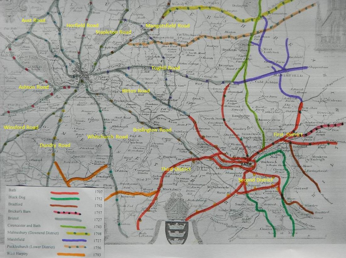
The Aust Road; the present Turnpike Road from the Top of Park Street, in the said City and County of Bristol, through the Village of Westbury and over Braintree Hill to Aust Passage in the Parish of Henbury, in the County of Gloucester, which shall be called The Aust Road ;
and the present Turnpike Road from the River or Brook at Westbury, crossing the said River or Brook through Part of the Village of Henbury into the said Aust Road at the Cross Hands or Direction Post near Cribbs Causeway; and the present Turnpike Road from the Cross Hands or Direction Post at or near Wain Bridge to the new Passage in the said Parish of Henbury;
and the Road (by this Act intended to be made Turnpike) from the Horfield Road, at or near the Pump at Redland, opposite the House of Mistreess Walker, into the said Aust Road at the North-eastward End of Durdham Dawn;
and the present Turnpike Road diverging from the said Aust Road, at a Place called The Limekilns on Durdham Dawn aforesaid, in the Parish of Clifton, through Stoke Bishop to Pill Passage in the Parish of Westbury-upon-Trym;
and the Road (by this Act intended to be made Turnpike) diverging from the said last mentioned Road at the Entrance into Lord De Clifford’s Park to or into the said Road in the Village of Henbury;
and the Road (by this Act intended to be made Turnpike) lately made across the South-eastward Side of Durdham Down, from the Cross Hands on the said Aust Road into the said Road leading to Pill Passage;
and a new Road (by this Act intended to be made) to lead across Durdham Down, from the said last mentioned Road into the said Road from the Village of Clifton ;
and the present Turnpike Road from the West End of Paul Strret in the Parish of Saint Michael in the said City and County of Bristol, into the said Aust Road at the Turnpike Gate called The White Ladies;
and the present Turnpike Road from the said City and County of .Bristol, at or near the Foot of Honeypen Hill, through the Village of Clifton, by the Church, and also by the House of Gabriel Goldney Esquire, over Clifton Down into the said Road leading to Pill Passage on Durdham Down ;
and the·present Turnpike Road diverging from the said Aust Road at or near the Entrance into Mr. Thomas Tyndall’s Park to the Southern End of Galsows Acre Lane;
and the Road (by this Act intended to be made Turnpike) leading from thence into the said last mentioned Road through the Village of Clifton,·
and the present Turnpike Road leading from the. Hotwell Road, at the Bottom of Clifton or Granby Hill, to the Top of they said Hill; and the Road (by this Act intended to be made Turnpike) leading from the Top of the said Hill into the said Road through the Village of Clifton at the Foot of Windmill Hill, and also into the same Road by Gloucester Row opposite the House of Mistress Miles Widow ;.
and the Road (by this Act intended to be made Turnpike) leading from the Bottom of Granby Hill aforesaid to the Hotwell Pump Room in the said Parish of Clifton;
also a new Road (by this Act intended to be made Turnpike) leading from the said Pump Room by the Side of the River and up the Hill, to or into the said Road leading from Clifton to Pill Passage at the Top of Bridge Valley ;
and the Road (by this Act intended to be made Turnpike) leading from thence along the Southward Side of Durdham Down into the said Aust Road at the Limekilns aforesaid; all which Roads pass through or lie in the Parishes of Saint Augustine the Less and Saint Michael in the City and County of Bristol; Clifton, Westbury·upon -·Trym, and Henbury, in the County of Gloucester, and City and County of Bristol, and shall be deemed and accounted Parts of the said Aust Road.
Horfield Road; The present Turnpike Road from the said City and County of Bristol, at or near Stokes Croft Turnpike Gate, through Horfield and Filton, over Almondsbury Hill and Milbury Heath, to the Church or Chapel at Stone, in the said County of Gloucester, which shall be called The Horfield Road ;
and the present Turnpike Road from the Ship at Avestone, through the Town of Thornbury, into the said Horfield Road at or near Buckover;
and the Road (by this Act intended to be made Turnpike) from-theWelt End of Paul Street in the City of Bristol, along Paul Street aforesaid and Portland Street into Cotham Lane, and along the said Lane to or into the·said Horfield Road at the Cross Hands or Direction Post at the Bottom of Lampblack Hill, in the said Parish of Westbury-upon-Trym ;
and the present Turnpike Road from the said last-mentioned Cross Hands or Direction Post, through the Village of Redland into the said Aust Road, at the·Cross Hands on Durdham Down aforesaid;
also a new Road (by this Act intended to be made) leading from the said Horfield Road at or near Catherine Place, in the Parish of Saint Paul in the said County of Gloucester, to or into the same Road near Cutlers Mills, in the same Parish;
also a new Road (by this Act intended to be made Turnpike) leading from the said Horfield Road at or near the Entrance into a Field in the Occupation of William Gold, in the Parish of Horfield in the said County of Gloucester, near a House called The Ship, to or into the same Road at or near the further End of the same Field, in the same Parish ;
also a new Road (by this Act intended to be made)leading from the said Horfield Road at or near a House in the Occupation of James William, situate at Buckover in the Parish of Thornbury in the said County of Gloucester, to or into the same Road at or near a House in the Occupation of Samuel Parnell, in the same Parish ; also a new Road (by this Act intended to be made) leading from the said Horfield Road on Horfield Common, in the said Parish of Horfield, through the Parishes of Horfield and Westbury - upon-Trym into the said Aust Road on Durdham Down, in the said Parish of Westbury-upon-Trym, and from thence over Part of the said Down into the said Road leading to Pill Passage at the entrance of the said Road leading to·Clifton, in the same Parish;
also a new Road (by this Act intended to be made) leading from the said Aust Road at or near Black Horse Hill, in the Parish of Henbury, at the Entrance into Greenway or Sands Lane along or by the said Lane, and of Hays Lane, into the said Horfield Road at the End of Hays Lane, and from thence through Lands on the Southward Side of Thoroughfare Lane to the End of Stoke Lane, where it joins the Lane leading to Harry Stoke; all which last-mentioned Roads pass through or lie in the several Parishes of Saint Paul, Saint James, Saint Philip and Jacob, Westbury-upon-Trym, Horfield, Filton, Stoke Gifford, Almondsbury, Olvestone, Alvestone, Thornbury, Berkely, Henbury, and Stapleton, in the County of Gloucester, and shall be deemed and accounted Parts of the Horfield Road.
The Stapleton Road; And the present Turnpike Road from the said City and County of Bristol at or near a Place called Lawford’s Gate, in the Parish of Saint Philip and Jacob, in the County of Gloucester, down Gloucester Lane, and by the new Prison for the County of Gloucester, through the Parishes of Saint Philip and Jacob, Stapleton, Winterbourue, Frampton Cotterell, and Iron Acton, in the said County, to the Village of Iron Acton, and the Road (by this Act intended to be made Turnpike) from thence through the same Village to a Common, lately inclosed, called Rangeworthy Common, which shall be called The Stapleton Road;
and the present Turnpike Road from the Stapleton Road aforesaid, near Begbrook, through Titherington, into the Horfield Road aforesaid, at Buckover in the said County of Gloucester, and passing through the Parishes of Winterbourne, Frampton Cotterell, .Alvestone, and Titherington ;
also the present Turnpike Road diverging from the said Stapleton Road at or near the Public House called The Blackbirds, to the Entrance into Stokes Croft, where the said Horfield Road commences; .
also a new Road (by this Act intended to be made) leading from the End of Newfoundland Street, where it joins Holton Street, situate partly in the Parish of Saint Paul in the said City and County of Bristol, and partly in the Parish of Saint Paul in the County of Gloucester, through the same Parishes into the said Stapleton Road, at the said Bridge over the River Frome at Baptist Mills aforesaid,
also a new Road (by this Act intended to be made) leading from the End of Stoke Lane aforesaid, where it joins the Lane leading to Harry Stoke aforesaid, in the Parishes of Stoke Gifford
and Winterbourne, or One of them, along or by the Side of the said Lane to the said Stapleton Road at Hambrook ;
and also a. new Road (by this Act intended to be made) leading from the said Stapleton Road, at a Spot between Frenchay and Hambrook, in the Parish of Winterbourne, by Frenchay, into the said Mangotsfield Road at Downend, in the Parish of Mangotsfeld, all which last-mentioned Roads pass through or lie in the City and County of Bristol, and County of Gloucester, and shall be deemed and accounted Part of the Stapleton Road;
Mangotsfield Road; The present Turnpike Road diverging from the said Stapleton Road, in the Parish of Stapleton, in the County of Gloucester, at or near the Black Swan Inn, through the Parishes of Stapleton and Mangotsfield to Mead Brook (which divides the Parishes of Mangotsfield and Pucklechurch), in the County of Gloucester, which shall be called The Mangotsfield Road ;
and the present Turnpike Road diverging from the said Mangotsfeld Road at or near a Place called The Fishponds, in the Parish of Stapleton, in the said County of Gloucester, and extending from thence through the Parishes of Stapleton, Mangotsfield, Frampton Cotterell, and Westerleigh, to Oxbridge, in the Parish of Westerleigh, in the County of Gloucester ;
also a new Road (by this Act intended to be made) leading from the said Mangotsfield Road at Downend aforesaid, in thc Parish of Mangotsfield over Mangotsfield Common, into the Mangotsfield Road near the Church, in the Village and Parish of Mangotsfield, and from thence over Rodway Hill and Webbs Heath, into the said Toghill Road, on Bridge Yate Common, in the Parish of Wick and Abson which last-mentioned Roads are in the County of Gloucester, and shall be deemed and accounted Part of the Mangotsfield Road.
Toghill Road; The present Turnpike Road diverging from the said Stapleton Road, at the Top of Gloucester Lane, through the Parishes of Saint Philip and Jacob, Saint George’s, Bitton, Siston, Wick and Abson, Doynton, and Cold Ashton, in the said County of Gloucester, into the Bath Road, at the Top of Toghill, in the Parish of Doynton, in the said County of Gloucester, which shall be called The Toghill Road;
also a new Road (by this Act intended to he made) leading from the said Toghill Road, on Bridge Yate Common aforesaid, in the said Parish of Wick and Abson, over North Common and Oldlands Common, and along or by the Side of a Lane called Cherry Garden Lane, into the Bitton Road at the End of the said Lane, in the Parish of Bitton, which
said Roads are in the County of Gloucester, and shall be deemed and accounted Part of the said Toghill Road :
Bitton Road; The present Turnpike Road diverging from the said Toghill Road at or near the new Church, in the said Parish of Saint George’s, and extending through the Parishes of Saint George’s and Bitton, in the County of Gloucester and of Northstoke, in the
County of Somerset, to Coombe Brook, in the Parish of Kelson, in the said County of Somerset, which shall be called The Bitton Road ,·
and the present Turnpike Road diverging from the said Bitton Road at Brockham Hill, in the Parish of Bitton, in the County of Gloucester, through the said Parish of Bitton to the Bridge over the Avon, near Keynsham, in the said County of Somerset, which shall he deemed and accounted Part of the said Bitton Road:
Brislington Road; The present Turnpike Road from Hill’s Bridge, in the said City and County of Bristol, through the Parishes of Saint .Mary Redcliffe, in the City and County of Bristol, and of Bedminster, Brislington, Keynsham, Saltford, Corston, and Newton Saint Loe, in the County of Somerset, to the Globe Inn, in the said Parish of Newton Saint Lee, which shall be called The Brislington Road;
and also the present Turnpike Road diverging from the said last-mentioned Road near the Church at Keynsham, and leading from thence to the Bridge over the Avon, near Keynsham aforesaid, in the said County of Somerset, which shall he deemed and accounted Part of the said Brislington Road, and which said last-mentioned Roads are situate in the City and County of Bristol, and County of Somerset :
Whitchurch Road; The present Turnpike Road diverging from the said Brislington Road at the Top of Totterdown Hill, in the said City and County of Bristol, and extending from thence through the Parishes of Saint Mary Redcliffe, Bedminster, Brislington, Whitchurch, Pensford, Publow, Chelwood, Clutton, Camely, and High Littleton, to White Cross, in the said Parish of High Littleton, in the said County of Somerset, which shall be called The Whitchurch Road ;
and a new Road (by this Act intended to be made) leading from the said Whitchurch Road, at or near a House in the Occupation of William Ford, in the Parish of Pensford, in the County of Somerset, crossing the River Chew, and also crossing the said Whitchurch Road at or near a House in the Occupation of John Price, in the Parish of Publow, into the said Whitchurch Road, about One hundred and forty Yards beyond the Seventh Milestone from Bristol, which said Road passes through the Parishes of .Pensford and Publow, in the County of Somerset and which said Roads shall be deemed and accounted Parts of the said Whitchurch Road:
Winsford Road; The present Turnpike Road from Harford’s Bridge in the said City and County of Bristol, through the Parishes of St Mary Redcliffe, in the said City and County, and of Bedminster, Long Ashton, Barrow, Winsford, Wrington, Burrington, Churchill, Rowborough, Shipham, Winscombe, Compton Bishop, Badgworth, Biddisham, and East Brent, in the said County of Somerset, to the Parish of South Brent, in the same County, which shall be called The Winsford Road.
Dundry Road; The present Turnpike Road diverging from the said Winsford Road at the Cross Hands on Bedminster Down, in the Parish of Bedminster, in the County of Somerset, and extending from thence through the Parishes of Bedminster Dundry, Chew Magna, Chew Stoke, Compton Martin, and Westharptry, in the said County of Somerset, to a Crossway leading from Westharptry to Chedder, in the said Parish of Westharptry, in the said County of Somerset, which shall be called The Dundry Road.
Ashton Road; The present Turnpike Road diverging from the said Winsford Road at or near the London Inn in Bedminster, in the Parish of Bedminster, in the County of Somerset, and extending from thence through the Parishes of Bedminster, Long Ashton, Flax Bourton, Backwell, Chelvey, and Brockley, to the Parish of Yatton, in the said County, near to a Place called Hortsbach, in the said Parish of Yatton, which shall be called The Ashton Road.
and the present Turnpike Road from the said Ashton Road at or near the West End of Horseman’s Green, in the Parish of Long Ashton, through the Parishes of Long Ashton, Abbotts Leigh, and Portbury, in the same County, to Pill Bridge, in the said Parish of Portbury;
and also the present Turnpike Road from the Said Ashton Road, at or near the Village of Long Ashton, in the said Parish of Long Ashton, through the same Parish, to the Cross Hands or Direction Post at the Top of Clerkencombe, in the said Parish of Long Ashton, which shall be deemed and accounted Parts of the Ashton Road;
also a new Road (by this Act intended to be made) leading from Harford’s Bridge aforesaid, in the said City and County of Bristol. by or near the new Course of the River Avon, through the Parishes of Saint Mary Redcliffe, in the City and County of Bristol, and of Bedminster, in the County of Somerset, into the Ashton Turnpike Road at or near the Entrance of the Lane leading to Clift House; also a new Road (by this Act intended to be made) leading from the said Ashton Road, in the Parish of Chelvey, in the said County of Somerset, near to West Town, through the Parishes of Chelvey and Brockley, in the same County, to or into the said Ashton Road at or near a House in the Occupation of William Cox the younger, in the said Parish of Brockley, which said Roads shall be deemed and accounted Parts of The Ashton Roads; and all which said last-mentioned Roads are situate in the City and County of Bristol, and County of Somerset.
In “Return of length of road in each Turnpike
Trust in England & Wales” Parl. Papers 1847-48 – (dated May 1848)
Trust reported 168
miles 4 furl. 0 yds (see 1840 was 173)
(a few of the roads
were identified and mapped in “Somerset Roads – the Legacy of Turnpike, by
Bentley and Murless 1985”)
Aust Road; A4018 from
Bristol to Westbury, then B4065 to Aust. UC roads in Westbury. B4064 from Pilning to New Passage. UC road
from Redland to Durdham (Clifton). A403 from Durdham, Stoke Bishop to Pill Passage. Other
UC in Clifton and Durdham.
Horfield
Road. A38
through Horfield, Filton
and Almondsbury to Stone, at the County Boundary.
B4061 from Alvestone to Thornbury. UC road from Horfield to Westbury. B road from Horfield to Redlands.
Stapleton Road; B4058 through Stapleton, Frenchay,
Winterbourne and Frampton to Iron acton
and Rangeworthy. B4427 from Begbroke, then UC road to Tytherington
to A38 jct at Buckover. UC
road to Harry Stoke. UC road and then A4174 to link
from Frenchay to Downend.
Mangotsfield Road; A432 through
Fishponds and Mangotsfield then B4465 to Mead Brook at
parish boundary with Pucklechurch. A432 from Fishponds to
Oxbridge, beyond Frampton. UC road from Downend, over Rodway Hill to Siston Common to jct on A420 at Warmley.
Toghill Road; A420 through
St George’s, siston and Wick to Tog Hill, jct with UC
road to Lansdown. A4175 from Bridgeyate
Common and Oldlands to Bitton
Bitton
Road; A431 from St George’s to Bitton into Kelston. A4175 from Willsbridge to Keynsham Bridge.
Brislington Road; A4 from
Bedminster, through Brislington to Corston, jct with A39. A4175 from Keynsham to Keynsham Bridge.
Whitchurch Road; A37 from
Bedminster, through Whitchurch, Pensford
and Clutton to White Cross, jct with A39. UC road over River Chew.
Winsford Road; A38 from Bedington through Churchill and Badgworth
to East Brent.
Dundry Road; UC road from
Bedminster Down, through Dundry and Chew Magna and
then B3114 to Westharptree.
Ashton Road; A370 from Bedminster to Long Ahton
(UC loop), and Brockley to Yatton
(Congresbury). A369 from Long Aston through Abbotts
Leigh to Pill bridge (Portbury).
B3128 from Long Ashton up Clerkencombe
(to Failand?). UC road from West Town, though Brockley to Claverham.
Click
here for a map of Bath & Bristol Turnpike Roads
Click
here for a map of Somerset Turnpike Roads
Click
here to return to Turnpikes Home
Return to Turnpikes in Gloucestershire general page
|
Road Classification Number |
Route |
GATE NAME |
OS Grid Ref- Prefi |
Easting |
Northing |
District |
Civil Parish |
Location (Name or Number) |
Road or Street (see across) |
Position |
Evidence |
erected by (Turnpike Trust or Authority) |
Bibliographic refs |
Revised 17th Oct 2013 |
Old County |
MSS National ID |
|||||
|
UC road |
Bristol to Wells |
Coronation Road (Ashton) |
ST |
57213 |
71754 |
AVBR |
BRISTOL |
Ashton Gate Toll House, 1-12, (No. 285) |
Coronation Road, Bedminster |
in front
of Toll House Court, jct with North Street |
OS 1st Series; ; ; |
Bristol |
Dowding J
& Taylor P. (2013) The Toll-Houses of Somerset , p 171; Census 1851;
Annals of Bristol in the 19th Century; Ashton District - gate closed in 1867.
Annals of Bristol in the 18th Century;
gate destroyed by Somerset farmers in 1749 |
SO |
AV.BRI01 |
||||||
|
A432 |
Bristol to Sodbury |
Blackbird |
ST |
60541 |
74243 |
AVBR |
BRISTOL |
Toll House, No. 250 Stapleton Road |
on corner of Oxford Place (set back from
frontage) |
OS 1st Series; ; ; old ticket |
Bristol |
|
GL |
AV.BRI03 |
|||||||
|
UC road |
Westbury to Aust
Passage |
Dial |
ST |
57459 |
77455 |
AVBR |
BRISTOL |
The Dial House |
Channell's
Hill Road, Westbury on Trym |
jct with Trym Road, in
the jct at bottom of hill before old bridge over River Trym |
; ; ; |
Bristol |
|
GL |
AV.BRI02 |
||||||
|
A4 |
Bristol to Brislington |
Arno's Vale |
ST |
603 |
716 |
AVBR |
BRISTOL |
Totterdown
area, Bedminster |
|
|
; ; ; old ticket |
Bristol |
Dowding J
& Taylor P. (2013) The Toll-Houses of Somerset , p 170; Census 1861 |
SO |
|||||||
|
B4058 |
Bristol to Frenchay |
Baptist Mills |
ST |
60 |
74 |
AVBR |
BRISTOL |
by Wesleyian chapel and
New Inn |
nr Bridge over River Frome |
|
; ; ; old Picture |
Bristol |
|
GL |
|||||||
|
A38 |
Bristol to Winford |
Bedminster |
ST |
577 |
707 |
AVBR |
BRISTOL |
between Old Bridewell
and Parson Street |
|
|
; ; ; |
Bristol |
Dowding J
& Taylor P. (2013) The Toll-Houses of Somerset , p 170; Census 1851 |
SO |
|||||||
|
A4 |
Bristol to Keynsham |
Brislington |
ST |
62 |
71 |
AVBR |
BRISTOL |
Bedminster |
|
|
; ; ; old Picture |
Bristol |
|
SO |
|||||||
|
A4032 |
Bristol to Downend |
Bristol |
ST |
60 |
74 |
AVBR |
BRISTOL |
Tollgate House, Houlton Street |
|
|
; ; ; |
Bristol |
|
GL |
|||||||
|
UC road |
Bristol to Clifton |
Clifton Down |
ST |
563 |
734 |
AVBR |
BRISTOL |
Clifton Down, top of Bridge Valley road - had a
rustic portico |
|
OS 1st Series; ; ; old picture |
Bristol |
Annals of Bristol in the 19th Century; Aust District - gate closed in 1867. |
GL |
||||||||
|
Bristol to Horfield |
Cutler's Mill |
ST |
AVBR |
BRISTOL |
|
|
|
Bristol |
Annals of Bristol in the 19th Century; Horfield District - gate closed in 1867. |
GL |
|||||||||||
|
A420 |
Bristol to Stapleton |
Lawford's |
ST |
607 |
734 |
AVBR |
BRISTOL |
Lawfords
Gate, St Phillips |
|
|
Bristol |
Annals of Bristol in the 19th Century; Stapleton
District - gate closed in 1867. |
GL |
||||||||
|
A420 |
Bristol to Bitton |
West Street |
ST |
60 |
73 |
AVBR |
BRISTOL |
West Street |
|
|
Bristol |
Annals of Bristol in the 19th Century; Togghill & Bitton District
- gate closed in 1867. |
GL |
||||||||
|
Bristol to Bitton |
Packhorse Lane bar |
ST |
60 |
73 |
AVBR |
BRISTOL |
|
|
|
Bristol |
Annals of Bristol in the 19th Century; Togghill & Bitton District
- gate closed in 1867. |
GL |
|||||||||
|
Bristol to Bitton |
Barrow Lane bar |
ST |
60 |
73 |
AVBR |
BRISTOL |
|
|
|
Bristol |
Annals of Bristol in the 19th Century; Togghill & Bitton District
- gate closed in 1867. |
GL |
|||||||||
|
Bristol to Wells |
Parson Street |
ST |
58 |
77 |
AVBR |
BRISTOL |
Parson Street (Highbury Road jct?) |
|
|
Bristol |
Annals of Bristol in the 19th Century; Dundry District - gate closed in 1867. |
SO |
|||||||||
|
Bristol to Aust |
Gallows Acre |
ST |
57 |
75 |
AVBR |
BRISTOL |
nr Whiteladies |
|
|
Bristol |
Annals of Bristol in the 19th Century; Aust District - gate closed in 1867. |
GL |
|||||||||
|
A37 |
Bristol to Whitchurch |
Knowle |
ST |
607 |
707 |
AVBR |
BRISTOL |
Upper Knowle |
|
|
; ; ; |
Bristol |
Dowding J
& Taylor P. (2013) The Toll-Houses of Somerset , p 170 |
SO |
|||||||
|
A37 |
Bristol to Dundry |
Luckwell
Lane |
ST |
57 |
71 |
AVBR |
BRISTOL |
nr Ashton
Gate (Luckwell Road) |
|
|
; ; ; |
Bristol |
Dowding J
& Taylor P. (2013) The Toll-Houses of Somerset ,
p 171; Annals of Bristol in the 19th Century; Dundry
District - gate closed in 1867. |
SO |
|||||||
|
A38 |
Bristol to Gloucester |
Montpellier |
ST |
59 |
74 |
AVBR |
BRISTOL |
Montpellier |
|
|
OS 1st Series; ; ; |
Bristol |
|
GL |
|||||||
|
A4 |
Bristol to Portishead |
Opp
Ashton |
ST |
57 |
73 |
AVBR |
BRISTOL |
|
|
|
OS 1st Series; ; ; |
Bristol |
|
GL |
|||||||
|
Bristol to Horfield |
Redland Road |
ST |
58 |
74 |
AVBR |
BRISTOL |
Redland Road |
|
|
Bristol |
Annals of Bristol in the 19th Century; Horfield District - gate closed in 1867. |
GL |
|||||||||
|
Bristol to Whitchurch |
St John's Lane (Don John's Cross) |
ST |
59 |
71 |
AVBR |
BRISTOL |
St John's Lane |
|
|
Bristol |
Annals of Bristol in the 19th Century; Whitchurcht District - gate closed in 1867. Annals of
Bristol in the 18th Century; gate
destroyed by Somerset farmers in 1749 |
SO |
|||||||||
|
UC road |
Bristol to Woolcott
Park |
St Michael's Hill |
ST |
583 |
735 |
AVBR |
BRISTOL |
Kingsdown
area |
|
|
; ; ; old Picture |
Bristol |
Annals of Bristol in the 19th Century; Aust District - gate closed in 1867. |
GL |
|||||||
|
A38 |
Bristol to Gloucester |
Stokes Croft |
ST |
59 |
74 |
AVBR |
BRISTOL |
Montpellier area |
|
mentioned in Act |
; ; named in 1819 Act; old Picture |
Bristol |
|
GL |
|||||||
|
A37 |
Bristol to Wells |
Totterdown |
ST |
699 |
716 |
AVBR |
BRISTOL |
Totterdown,
Wells Road, jct with St John's Lane |
|
; ; ; |
Bristol |
Dowding J
& Taylor P. (2013) The Toll-Houses of Somerset , p 170; Census 1851 |
SO |
||||||||
|
A4018 |
Bristol to Westbury |
White Ladies |
ST |
578 |
740 |
AVBR |
BRISTOL |
White Ladies |
|
|
OS 1st Series; ; named in 1819 Act; |
Bristol |
Annals of Bristol in the 19th Century; Aust District - gate closed in 1867. |
GL |
|||||||
|
A37 |
Bristol to Whitchurch |
Chelwood |
ST |
62435 |
62061 |
AVBS |
CHELWOOD |
Tyreece |
Whitley Batts Road |
just N of the Chelwood
Bridge roundabout |
OS 1st Series; ; ; |
Bristol |
Dowding J
& Taylor P. (2013) The Toll-Houses of Somerset , p 172; Census 1861 |
SO |
AV.CHE |
||||||
|
B3114 |
Chew Magna to West Harptree |
Chew Stoke |
ST |
55914 |
61593 |
AVBS |
CHEW STOKE |
Turnpike Cottage |
Stoke Hill |
nr Stoke Inn |
; ; ; |
Bristol |
Dowding J
& Taylor P. (2013) The Toll-Houses of Somerset , p 169; Census 1861 |
SO |
AV.CHS |
||||||
|
A4 |
Bath to Bristol |
Saltford |
ST |
68861 |
66474 |
AVBS |
SALTFORD |
Old Turnpike, No. 532 |
Bath Road |
on corner approaching from Bath |
Bristol |
Dowding J
& Taylor P. (2013) The Toll-Houses of Somerset , p 173; Census 1871 |
SO |
AV.SAL |
|
||||||
|
A37 |
Bristol to Wells |
Whitchurch |
ST |
613 |
677 |
AVBS |
WHITCHURCH |
corner of Maggs Lane |
|
|
; ; ; |
Bristol |
Dowding J
& Taylor P. (2013) The Toll-Houses of Somerset , p 172 |
SO |
|||||||
|
A370 |
Bristol to Congresbury |
Blackwell |
ST |
49 |
69 |
AVNS |
BACKWELL |
attacked in 1749 riots |
|
|
; ; ; |
Bristol |
Dowding J
& Taylor P. (2013) The Toll-Houses of Somerset , p 173 |
SO |
|||||||
|
A38 |
Bristol to Bridgwater |
Churchill |
ST |
448 |
598 |
AVNS |
CHURCHILL |
next gate to Sidcot;
mentioned on Sidcot plaque |
jct with A368 |
|
OS 1st Series; ; ; |
Bristol |
Dowding J
& Taylor P. (2013) The Toll-Houses of Somerset , p 168; Census 1861 |
SO |
|||||||
|
UC road |
Bristol to Wells |
Dundry |
ST |
56 |
67 |
AVNS |
DUNDRY |
attacked in 1749 riots |
|
|
; ; ; |
Bristol |
Dowding J
& Taylor P. (2013) The Toll-Houses of Somerset , p 173 |
SO |
|||||||
|
A369 |
Bristol to Pill |
Rownham |
ST |
564 |
726 |
AVNS |
LONG ASHTON |
|
Rownham
Hill |
|
; ; ; |
Bristol |
Dowding J
& Taylor P. (2013) The Toll-Houses of Somerset , p 169; Census 1851 |
SO |
|||||||
|
Bristol to Nailsea |
Nailsea |
ST |
47 |
70 |
AVNS |
NAILSEA |
attacked in 1749 riots |
|
|
; ; ; |
Bristol |
Dowding J
& Taylor P. (2013) The Toll-Houses of Somerset , p 173 |
SO |
||||||||
|
B3124 |
Portishead
to Clevedon |
Portishead |
ST |
46671 |
76696 |
AVNS |
PORTISHEAD AND NORTH WESTON |
No. 1 |
Woodhill
Road |
|
; ; ; |
Bristol |
- |
SO |
AV.POR |
||||||
|
A371 |
Bristol to Bridgwater |
Sidcot |
ST |
42611 |
57355 |
AVNS |
WINSCOMBE AND SANDFORD |
Sidcot
Gate Toll House |
Sidcot
Lane, jct with Bristol Road |
blue plaque indicating was part of Bristol TP
trust |
; ; ; |
Bristol |
Dowding J
& Taylor P. (2013) The Toll-Houses of Somerset , p 167; Census 1861 |
SO |
AV.WIN |
||||||
|
UC road (off B4427) |
Iron Acton to Rudgeway |
Rudgeway |
ST |
6362 |
8805 |
AVSG |
ALVESTON |
The Bungalow |
Church Road |
on cut off section of road net to old abandoned
church at Rudgeway |
; ; ; |
Bristol |
- |
GL |
AV.ALV |
||||||
|
A4175 |
Bitton
to Bridge Yate |
Oldlands |
ST |
67250 |
70659 |
AVSG |
BITTON |
Turnpike Cottage |
Barry Road |
jct with Cherry Garden Lane, opp. Chief Trading
Post Nurseries |
OS 1st Series; ; ; |
Bristol |
- |
GL |
AV.BIT |
||||||
|
A431 |
Bristol to Bath |
Willsbridge |
ST |
6658 |
7035 |
AVSG |
BITTON |
94A Bath Road (former Weighbridge) |
jct with Keynsham Road |
|
OS 1st Series; ; ; |
Bristol |
|
GL |
|||||||
|
A431 |
Bristol to Bath |
Bitton |
ST |
686 |
694 |
AVSG |
BITTON |
|
|
|
OS 1st Series; ; ; |
Bristol |
|
GL |
|||||||
|
UC road |
Old Road Iron Acton to Bristol |
Iron Acton |
ST |
67639 |
83419 |
AVSG |
IRON ACTON |
Turnpike House |
Station Road |
on bend where short lane to station branches off
road to by-pass |
; ; ; |
Bristol |
- |
GL |
AV.IRO01 |
||||||
|
B4427 |
Old Bristol to Gloucester |
Froglands
Cross |
ST |
6445 |
8379 |
AVSG |
IRON ACTON |
Turnpike Cottage, Froglands
Cross |
Old Gloucester Road, Gaunt's
Earthcott |
at jct with Gaunt's Earthcott Lane |
; ; ; |
Bristol |
- |
GL |
AV.IRO03 |
||||||
|
UC road |
Mangotsfield
to Frenchay |
Cleeve
Wood |
ST |
64462 |
77677 |
AVSG |
KINGSWOOD |
Turnpike Cottage (Cleeve
Wood Lodge) |
Cleeve
Wood Road |
eastern side of bridge, on slope to river |
; ; ; |
Bristol |
- |
GL |
AV.KIN01 |
||||||
|
B4427 |
Old Bristol to Gloucester |
Hambrook |
ST |
64052 |
78734 |
AVSG |
KINGSWOOD |
Tollhouse |
Bristol Road, opp. Hambrook
House, next to The Old Post House |
opp. The Stream, 250m N of jct with Ring Road |
; ; ; |
Bristol |
- |
GL |
AV.KIN02 |
||||||
|
A432 |
Mangotsfield
to Yate |
Wick (Kendleshire) |
ST |
661 |
787 |
AVSG |
MANGOTSFIELD RURAL |
jct S of Kembleshire
Common |
|
|
OS 1st Series; ; ; |
Bristol |
|
GL |
|||||||
|
UC road |
Mangotsfield
to Yate |
Siston
Common |
ST |
6686 |
7451 |
AVSG |
SISTON |
Sunney
View Boarding Kennels (was Seven Winds) |
Siston
Common |
at jct to Goose Green |
; ; ; |
Bristol |
- |
GL |
AV.SIS |
||||||
|
A420 |
Bristol to Chippenham |
Bridge Yate Common |
ST |
6800 |
7328 |
AVSG |
SISTON |
Bridgeyate
Common |
now scrub |
|
; ; ; |
Bristol |
|
GL |
|||||||
|
A38 |
Bristol to Gloucester |
Thornbury |
ST |
6837 |
9329 |
AVSG |
THORNBURY |
Moorslade
Lane |
jct with B4510 |
|
; ; ; |
Bristol |
|
GL |
|||||||
|
A38 |
Bristol to Bridgwater |
Badgworth |
ST |
39294 |
53232 |
SOSG |
BADGWORTH |
Turnpike Cottage |
Church Lane |
at jct of road to Badgworth |
; ; ; |
Bristol |
- |
SO |
SO.BAD |
||||||
|
UC road (was old Bristol Road) |
Bristol to Bridgwater |
Cross (Compton) |
ST |
412 |
547 |
SOSG |
COMPTON BISHOP |
assume this is at Cross on old coach road jct |
on plaque at Sidcot |
|
; ; ; |
Bristol |
Dowding J
& Taylor P. (2013) The Toll-Houses of Somerset , p 168; Census 1861 |
SO |
|||||||
In the Milestone Society Database, 81 milestones are identified along this road. Based on the mileage reported by the Trust in 1840, would expect 173. Most are metal plates (some incised) attached to stones, some of which have earlier engravings. A series of cast iron posts, dated 1837, run to Cross
Extracts from The Annals of Bristol in the Eighteenth Century, by JOHN LATIMER– digitised by Google
1726.
In 1726, when a report was made to the Council
that the roads leading to the city were “ extremely ruinous,"
a vote of £100 was made for their repair. But it was seen that more effectual
measures were necessary, and a petition was presented to Parliament in the
following session praying for power to erect turnpike gates. Evidence was given
before a committee of the Commons as to the urgency of the case. It was deposed
that all the roads near the city were dangerous to passengers, and that part of
the London road, and several of the highways near Sodbury
and Wotton-under-Edge, were not wide enough to allow two horses, going in
opposite directions, to pass each other. A witness swore that one of his horses
had been suffocated in the mud, and another that his team had been saved from a
slough only by being pulled out by ropes. The road to Bath from Temple Gate to Totterdown was still only seven feet wide. The Bill
received the Royal assent in April, 1727. It enacted that the members of
Parliament for Bristol, Gloucestershire, and Somerset, the justices of the two
shires, the members of the Corporation, and a great number of local gentry
should be appointed trustees for the reparation of the roads, with power to
levy tolls. Wagons, etc., with six horses or oxen were to pay 1s., with four 8d., with two 4d., and with one 2d, ; a pack
horse Id., if with coals ^d ; there were also tolls for cattle and sheep. The
limits of the trust extended from about ten to twelve miles on the chief roads out
of Bristol, and the tolls were to continue for twenty-one years only. In
accordance with the terms of the Act, turnpike gates were set up in order that
tolls might be first collected on the 26th June. But the trustees forgot that they
would have to reckon with the lawless mining population of Kingswood,
roused to wrath by the charge imposed on the horses and donkeys which brought
coal into the city. The colliers assembled in great numbers and pulled down all
the gates, burning some, and throwing one barrier into the Avon. The mayor's
letter to the Government, dated the 28th, and detailing the proceedings, is
amongst the State Papers. His worship wrote : — "
They are a set of ungovernable people, regardless of consequences. They extort
money of people as they pass along the road, and treat them very rudely unless
they give them some. They have passed through this city with clubs and staves
in a noisy manner, but committed no violence here. I am persuaded, had any opposition
been made, the consequences would have been fatal." Some of the gates were
again erected, only to be demolished in a few hours, and the colliers would
suffer no coal to enter the city. The price of fuel, ordinarily sold at Is. a horseload, having risen to 2s. 3d., the Council, on the 28th,
ordered off messengers to " Swazey, [Swansea],
to buy cole on account of the Chamber " for the
use of the citizens — which turned out a somewhat costly procedure, for the Kingswood men returned to work, and the Welsh coal, when it
arrived, had to be sold at a loss of £215, exclusive of £4 5s. worth of wine sent to the Customs Collector at " Swanzy " for his services. The turnpike trustees,
supposing the disturbances at an end, had the toll-gates reconstructed; but the
colliers again rose, and burnt the gate " near Durdham Down." Further outrages were prevented by a
body of soldiers, who captured four of the rioters, and the gate was restored.
But on the night after the troops had embarked for Ireland, all the gates were
again demolished by men disguised in women's clothes and wearing high-crowned hats.
To complete the joy of the mischief makers, the four men committed to prison
had to be released. Parliament having omitted to impose any
penalty upon assailants of turnpikes. After vainly struggling to perform
their functions, the trustees asked for further legislative powers in 1730,
stating that through their inability to borrow money, the roads remained wholly
unimproved. It was hoped that by allowing animals carrying coal to pass toll
free, no further difficulty would be encountered, but the remission had little
effect. In the State Papers is a letter from Sir W. Codrington
to the Duke of Newcastle, dated July 14th, 1731, stating that the house of Mr. Blathwaite, of Dyrham, who had
made himself obnoxious by attempting to defend the turnpikes, had been attacked
by 400 colliers, who threatened to demolish it. The writer rode to the spot
with twenty of his tenants and servants; but he was forced to release four of
the rioters previously captured, and to give the rest a hogshead of ale, before
they would depart. Nearly all the gates were then down. The following is highly
significant : — " I am afraid, my lord, these
wretches would never have been so impudent if they had not been prompted by men
of some fortune and figure ; and we have been informed that two or three
bailiffs, as we call them, to some gentlemen, were seen to be a-drinking with
the colliers the evening before they were at Mr. Blathwaiters.*'
A week later, in a . letter dated from Bristol, Sir
William reports that " the insolencies of the
rioters are greater than ever, they having cut down some of the gates even at
noon day, and are now collecting money of travellers where the gates stood. . .
. The remaining part of the inhabited turnpike house at Yate was burnt down
last night." Troops were sent to Bristol, but inspired no terror amongst
the rioters, who continued to defy the law. The destructive spirit of the Kingswood men was singularly manifested in the following
year, when a large body marched to Chippenham, and
demolished the turnpike gate at Ford, near that town {London Journal, Sept.
23rd). Two years later, June, 1734, every gate between Bristol and Gloucester
was destroyed by armed bands. In August, 1735, Sir William Codrington
informed the Duke of Newcastle that the colliers still held the roads,
sometimes extorting 50s. in a single day, and that if
the Government would not render more help, " God knows how it may end' He
added that a bailiff named Prichet, at Westerleigh, was " at the bottom of the whole
affair." To complete the chaos, the rural trustees quarrelled with those
representing Bristol; and Oldmixon, writing in 1735,
asserted that "the roads, as bad as most in England, remain unrepaired to
this day' Four years later, Ralph Allen, of Bath, in giving evidence on behalf
of a local turnpike Bill, deposed that the Bristol Acts were still inoperative,
"by reason the colliers have pulled down, and do constantly pull down, the
turnpikes."
1749
In February, 1749, the Bristol turnpike
trustees forwarded a petition to the House of Commons, setting forth that,
notwithstanding the Act of 1727, the roads were still, owing to various causes,
in as ruinous a condition as before the trust was created, and praying for a
renewal of the powers about to expire. A petition was also presented on behalf
of several of the neighbouring gentry, asking that certain "
ruinous " roads, not included in the former Act, might be embraced
in the new statute. The Bill, with extended powers, received the Royal Assent
in May. In the hope of allaying discontent, carts laden with coal were exempted
from toll. The farmers, however, had always detested the turnpikes, and the
inclusion of additional roads in the trust irritated them into open revolt.
During the month of July great bodies of rural labourers, styling themselves
" Jack a Lents," some wearing shirts over their clothes, others naked
to the waist, and all with blackened faces, twice destroyed the gates at
Bedminster, Ashton and Don John's Cross, and threatened an attack on the city.
On the 1st August, they came for the third time, with drums, colours, and arms,
and demolished the toll houses on the Ashton and Dundry
roads. Headed by a young gentleman-farmer of Nailsea
carrying an improvised standard, they next proceeded
to Bedminster, to be avenged on Stephen Durbin, the tything
man, who had caused three rioters to be captured during the previous raids.
After drinking freely they attacked Durbin's house, which by order of their
leader was levelled with the ground. Subsequently the mob, finding Redcliff
Gate closed, made its way to Totterdown, where it
demolished the two gates and houses. The magistrates, aided by a number of
constables and fifty sailors armed with cutlasses, at length appeared on the
scene, and after severe fighting, in which one Farmer Barns, was conspicuous as
a rioter, about thirty men, several of them severely wounded, were arrested on Knowle Hill. An affair so congenial with their habits would
have excited the Kingswood colliers, even if the
Somerset farmers had not prompted them with bribes. On the 3rd August they
assembled in force, and almost all the remaining tollgates were burnt or
destroyed by gunpowder, money being demanded from every traveller as a reward
for this patriotic service. On the arrival of a regiment of dragoons the disturbances
ceased, but letters were sent to the Council House threatening to blockade and
burn the city if the arrested rioters were not released. (Five of these
prisoners died in Newgate from smallpox.) The judges
of assize were on circuit during the tumults, and special precautions had to be
taken for their safety. The recorder was stopped at Pensford
by a turbulent mob, which demanded money, but his firmness awed the rabble, and
he was allowed to proceed. The Kingswood colliers
maintained a nightly guard for several weeks after the riots, in order to
defeat any attempt of the authorities to capture the ringleaders. In the correspondence
between the mayor and the Government, part of which is in the British Museum,
the inactivity displayed by the county gentry throughout the tumults is said to
have increased the difficulties of the magistrates. (In a private account book
of Mr. Gore, of Barrow Court, is the following remarkable entry: — August 26,
1753. To Mr. Hardwick, on my account, for cutting down the
turnpikes, £10.) The sympathy of the farmers with the rioters was so
unconcealed that the trials of eighteen of the Somerset prisoners were removed
to Wiltshire; but not a single conviction was obtained there, the juries
acquitting the ringleaders in spite of the clearest evidence of their guilt.
Two men, concerned in pulling down Mr. Durbin's house, were condemned in
Somerset on the testimony of an accomplice, and were executed at Ilchester.
Their fate caused a deep sensation; and the rural war against turnpikes,
maintained obstinately for upwards of twenty years, was at length sullenly abandoned.
The improved roads, however, were long disliked by persons of conservative
instincts. Nearly thirty years after this date Mr. Windham recorded in his
diary Dr. Johnson's strong hostility to them. " Formerly,"
said the sage, " there were cheap places and dear places. Now all refuges were
destroyed for elegant or genteel poverty, and men had no longer a hope to
support them in their struggle through life. The roads moreover caused disunion
of families by furnishing a market to each man's abilities, and destroying the
dependence of one man on another."
1757
A Bill for the extension of local turnpikes
having been brought into the House of Commons in 1758, some of the turnpike
trustees petitioned for the inclusion in the measure of two more highways,
namely, the road through Stoke Bishop to Shirehampton,
and the road to Aust (the Welsh mail route), which
" was up a very steep hill (Steep Street) going out of Bristol." To
avoid the latter difficulty, the petitioners suggested that a new turnpike road
should be made from Frog Lane " through certain
grounds (the site of Park Street) to a gate on the Aust
road called the White Lady's Gate." Clauses carrying out these proposals
were introduced into the Bill, which became law. It was not until October,
1761, however, that the trustees resolved to proceed with the Whiteladies improvement. The Shirehampton
turnpike opened out that district to the fashionable throng at the Hot Well,
and excursions to Kingsweston inn and Penpole Hill became popular. For the accommodation of visitors
to the latter, a building called the Breakfasting Room was erected, the patrons
of which were permitted to ramble in the shrubberi.es of Kingsweston
House.
1774
In the session of 1774 a Bill was promoted
by the Bristol turnpike trustees for a renewal of their powers, then about to
expire, and for the inclusion in the trust of Gallows Acre Lane, of the road
from the top of Park Street to the bottom of Clifton Hill, of the lane from Stoke's Croft to the Blackbirds Inn Gate, Stapleton Road,
and of the road from Gallows Acre Lane to Whiteladies'
Road. The two last named proposals excited much local agitation, and petitions against
them were adopted by the poor law guardians and by a public meeting of the
citizens, on the ground that the large traffic between the Hot Well and Bath,
as well as that between Wales and the South of England, then passing through
Bristol, would be diverted, to the great loss of the inhabitants. The
opposition was successful in forcing the trustees to modify their scheme. Power
to make a turnpike road from the top of Stokers Croft to Stapleton Road was, however,
obtained a few years later, and Ashley Road was opened in 1786.
1833
During the summer of 1833 the trustees of
the Bristol turnpikes, with a view to improving the chief southern entrance to
the city, caused a deep cutting to be made at Totterdown,
near the junction of the Wells road with that from Bath. A very steep hill
there, much disliked by stage coachmen, was thus practically removed. A similar
improvement was effected at the same time near Clifton church, a new road being
cut in front of Goldney House.
1866
At the annual meeting of the Bristol Turnpike
trustees, in March, 1866, it was reported that the mortgage debt upon the
entire trust which embraced 163 miles of road, and was, with one exception, the
most extensive in England had been nearly paid off. The only charge remaining
was one of £5,500 two of the northern sections. As the surplus receipts for a
further period of eighteen months would clear off this burden, it was resolved
that the tolls should be abolished on the Ist
November, 1867. The resolution was carried by the narrow majority of 26 votes
against 22, many of the rural trustees being opposed to a step which threw the
maintenance of the roads on the local ratepayers, whilst some of the Bristol
trustees objected that the abolition of tolls would entail a burden of £2,000 a
year upon the citizens for repairing the eighteen miles of turnpike within the
borough. In accordance with the resolution, the district was included in the
Turnpike Act of 1866, under the provisions of which the powers of the trustees
expired on the 1st November, 1867 when all the turnpike gates were removed.
Within the borough there were no less than fifteen of those obstacles to
locomotion, namely : Whiteladies, St. Michael's,
Clifton Down and Gallows Acre gates in the Aust
district ; Cutler's Mills and Redland Road gates in the Horfield
district ; St. John's Lane gate in the Whitchurch
district ; Lawford's and Baptist Mills gates in the
Stapleton district; West Street gate, and bars at Packhorse and Barrow Lanes in
the Toghill and Bitton
district ; Parson Street and Luckwell Lane gates in
the Dundry district; and Coronation Road gate in the
Ashton trust. The sites of the toll-houses were in most cases claimed by the
owners of the adjoining property, and the buildings were demolished.* The surplus funds of the trust (£6,760) were divided amongst
the local highway authorities.
The Clifton
toll-house at the top of Bridge Valley Road had a large rustic portico, under
which the public were accustomed to take shelter during sudden showers of rain.
A member of the Council proposed that the construction should be preserved for
the sake of its utility ; but his suggestion met with
no support, and promenaders are worse off now than
they were twenty years ago.